
Mapa topográfico San Cristóbal Totonicapán
Mapa interactivo
Haga clic en el mapa para ver la altitud.
Acerca de este mapa
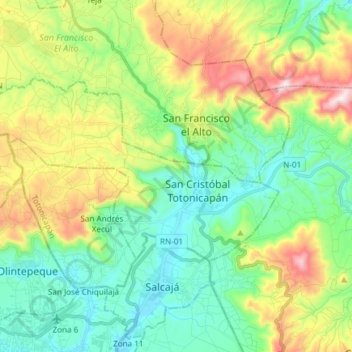
Nombre: Mapa topográfico San Cristóbal Totonicapán, altitud, relieve.
Lugar: San Cristóbal Totonicapán, Totonicapán, Guatemala (14.88917 -91.55734 14.95846 -91.40805)
Altitud media: 2,561 m
Altitud mínima: 2,312 m
Altitud máxima: 3,091 m
Otros mapas topográficos
Haga clic en un mapa para ver su topografía, su altitud y su relieve.
Santa Lucía la Reforma
Guatemala > Totonicapán > Santa Lucía La Reforma
Santa Lucía la Reforma, Santa Lucía La Reforma, Totonicapán, Guatemala
Altitud media: 1,860 m
San Andrés Xecul
San Andrés Xecul, Totonicapán, Guatemala
Altitud media: 2,586 m
San Francisco El Alto
San Francisco El Alto, Totonicapán, Guatemala
Altitud media: 2,671 m
Santa Lucía La Reforma
Santa Lucía La Reforma, Totonicapán, Guatemala
Altitud media: 1,808 m