
Haz una donación
Mapa topográfico Ladaj
Haga clic en el mapa para ver la altitud.
Haz una donación
Ladaj
Las cadenas montañosas en esta región se formaron durante un período de 45 millones de años mediante el choque y plegado de la Placa India contra la Placa Euroasiática. El desplazamiento continúa hoy hacia el Norte, siendo el causante de frecuentes terremotos en la zona de los Himalayas. Los picos en la cordillera de Ladakh poseen altitudes intermedias en la zona de Zoji-la (5000 a 5500 m), y aumentan hacia el sureste, alcanzando un máximo en las cumbres gemelas del Nun Kun (7000 m).
Haz una donación
Acerca de este mapa
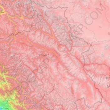
Nombre: Mapa topográfico Ladaj, altitud, relieve.
Lugar: Ladaj, India (32.33574 75.32697 35.67455 79.46075)
Altitud media: 4,726 m
Altitud mínima: 337 m
Altitud máxima: 7,470 m
Haz una donación
Otros mapas topográficos
Haga clic en un mapa para ver su topografía, su altitud y su relieve.