
Haz una donación
Mapa topográfico Megalaya
Haga clic en el mapa para ver la altitud.
Haz una donación
Megalaya
Las montañas Garo, al oeste, y las montañas Khasi y las Jaintia, al este, no tienen picos extremadamente altos, y el punto de mayor altitud es el Pico Shillong, con una altura de 1.965 m s. n. m.[cita requerida]
Haz una donación
Acerca de este mapa
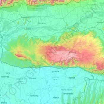
Nombre: Mapa topográfico Megalaya, altitud, relieve.
Lugar: Megalaya, India (25.03065 89.81444 26.11817 92.80274)
Altitud media: 244 m
Altitud mínima: 0 m
Altitud máxima: 2,336 m
Haz una donación
Otros mapas topográficos
Haga clic en un mapa para ver su topografía, su altitud y su relieve.
Bangalore
India > Karnataka > Bangalore North
Bangalore se encuentra en el sureste de la región meridional del estado indio de Karnataka. Localizada en el corazón de la meseta de Mysore (una región de la gran meseta del Decán) tiene una elevación media de 920 m.
Altitud media: 879 m
Leh
India > Ladaj > Leh Tehsil
Leh fue la antigua capital del reino de Ladakh en los himalayas. Actualmente lo es del distrito de Leh y del territorio de Ladakh, India. En el pueblo aún se destacan las ruinas del palacio de Leh, dicho palacio era la residencia de la familia real de Ladakh, que es similar a una copia reducida del palacio…
Altitud media: 3,653 m
Haz una donación
Haz una donación
Haz una donación
Jaynagar Majilpur
India > Bengala Occidental > Jaynagar - I
Se encuentra a una altitud de 8 m s. n. m. a 49 km de la capital estatal, Calcuta, en la zona horaria UTC +5:30.
Altitud media: 5 m
Haz una donación
Haz una donación