
Mapa topográfico Aguascalientes
Mapa interactivo
Haga clic en el mapa para ver la altitud.
Aguascalientes
Por situarse al sur del Trópico de Cáncer y con una altitud de 1,880 msnm, su temperatura media anual es de 18 °C. El mes más cálido es junio; y el más frío, enero. La oscilación de la temperatura no es mayor a 10 °C. El clima en la ciudad (como en todo el Valle de Aguascalientes) es estepario o ligeramente continental. La precipitación anual promedio es de 500 mm, y la temporada de lluvias es el verano (iniciando a finales de junio y terminando a finales de septiembre).
Acerca de este mapa
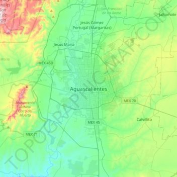
Nombre: Mapa topográfico Aguascalientes, altitud, relieve.
Altitud media: 1,956 m
Altitud mínima: 1,777 m
Altitud máxima: 2,514 m
Otros mapas topográficos
Haga clic en un mapa para ver su topografía, su altitud y su relieve.
El Cedazo
México > Aguascalientes > Municipio de Aguascalientes > Aguascalientes
Altitud media: 1,911 m