
Mapa topográfico Manitoulin District
Mapa interactivo
Haga clic en el mapa para ver la altitud.
Acerca de este mapa
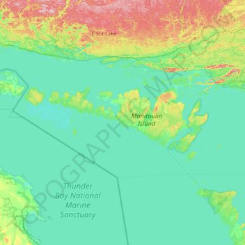
Nombre: Mapa topográfico Manitoulin District, altitud, relieve.
Lugar: Manitoulin District, Ontario, Canadá (45.36070 -83.50673 46.13040 -81.07103)
Altitud media: 211 m
Altitud mínima: 171 m
Altitud máxima: 529 m
Otros mapas topográficos
Haga clic en un mapa para ver su topografía, su altitud y su relieve.
Grand River
Grand River, Wellington County, Southwestern Ontario, Ontario, N0B 2V0, Canadá
Altitud media: 300 m
Lago de los Bosques
Canadá > Ontario > Lake of the Woods
Lago de los Bosques, Lake of the Woods, Rainy River District, Northwestern Ontario, Ontario, P0X 1C0, Canadá
Altitud media: 337 m
Lake Simcoe
Lake Simcoe, Georgina, York Region, Golden Horseshoe, Ontario, L3Y 7C1, Canadá
Altitud media: 247 m
Lago Nipigon
Canadá > Ontario > Unorganized Thunder Bay District
Lago Nipigon, Unorganized Thunder Bay District, Thunder Bay District, Northwestern Ontario, Ontario, Canadá
Altitud media: 307 m
Windermere Lake
Canadá > Ontario > Unorganized South Nipissing
Windermere Lake, Unorganized South Nipissing, Nipissing District, Ontario, Canadá
Altitud media: 355 m
Manitoulin Island
Canadá > Ontario > Northeastern Manitoulin and the Islands
Manitoulin Island, Northeastern Manitoulin and the Islands, Manitoulin District, Ontario, Canadá
Altitud media: 202 m
Victoria Island
Victoria Island, (Old) Ottawa, Ottawa, Ontario, K1R 1C5, Canadá
Altitud media: 126 m