
Gracias por apoyar a este sitio ❤️
Haz una donación
Haz una donación
Mapa topográfico Surat
Haga clic en el mapa para ver la altitud.
Gracias por apoyar a este sitio ❤️
Haz una donación
Haz una donación
Surat
La ciudad se sitúa en el margen izquierdo del río Tapi, a 22 km de su desembocadura. Si bien es una ciudad con puerto, este ha sido dañado por el río, por lo que se usa como tal el puerto de Hazira en el área metropolitana de Surat. Surate se localiza a latitud 21°10′12″ N y longitud 72°49′48″ E, a una altitud de 13 m s. n. m.
Gracias por apoyar a este sitio ❤️
Haz una donación
Haz una donación
Acerca de este mapa
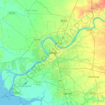
Nombre: Mapa topográfico Surat, altitud, relieve.
Lugar: Surat, Katargam Taluka, Surat, Guyarat, 395008, India (21.04949 72.67171 21.36949 72.99171)
Altitud media: 13 m
Altitud mínima: -3 m
Altitud máxima: 38 m
Gracias por apoyar a este sitio ❤️
Haz una donación
Haz una donación