
Mapa topográfico Tequixquiac
Mapa interactivo
Haga clic en el mapa para ver la altitud.
Tequixquiac
Tequixquiac como zona orográfica comprende la transición del valle de México hacia el valle del Mezquital, la altitud máxima del municipio es de 2620 msnm y su cabecera municipal (Santiago Tequixquiac) se encuentra a 2.340 msnm. Tiene una superficie de aproximada de 96 km², que corresponden al 0.36% de la superficie del estado.
Acerca de este mapa
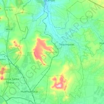
Nombre: Mapa topográfico Tequixquiac, altitud, relieve.
Lugar: Tequixquiac, Estado de México, México (19.82282 -99.22776 19.96444 -99.05861)
Altitud media: 2,296 m
Altitud mínima: 2,167 m
Altitud máxima: 2,705 m
Otros mapas topográficos
Haga clic en un mapa para ver su topografía, su altitud y su relieve.
Nevado de Toluca
México > Estado de México > Toluca
Alcanza una elevación de 4680 m s. n. m., por lo que es la cuarta formación más alta de México y forma parte de la Cordillera Neovolcánica Transversal y del Cinturón de Fuego del Pacífico. Por el este se une a la Sierra de Tenango, por el noroeste a los montes de la Gavia, por el oeste a la Sierra de…
Altitud media: 4,280 m
Chiautla
México > Estado de México > Chiautla
El municipio se encuentra a una altitud de 2,258 metros sobre el nivel del mar. El municipio de Chiautla se localiza en la porción oriente del Estado de México y colinda la norte con el municipio de Acolman, al sur con el municipio de Texcoco, al oriente con los municipios de Tepetlaoxtoc y Papalotla; y al…
Altitud media: 2,261 m
San Miguel Hojas Anchas
México > Estado de México > Zinacantepec > Barrio De México
Altitud media: 2,960 m
Nezahualcóyotl
México > Estado de México > Nezahualcóyotl > Nezahualcóyotl
El municipio se encuentra a una altitud promedio de 2,220 msnm.
Altitud media: 2,262 m
Chalco de Díaz Covarrubias
México > Estado de México > Chalco > Chalco de Díaz Covarrubias
Altitud media: 2,515 m
San Miguel Xaltocan
México > Estado de México > Nextlalpan > San Miguel Xaltocan
Altitud media: 2,241 m
Ecatepec de Morelos
México > Estado de México > Ecatepec de Morelos > Ecatepec de Morelos
Ecatepec se ubica al noreste del Estado de México y al norte del valle de México, siendo parte de la zona metropolitana del Valle de México. El municipio se ubica entre los paralelos 19° 29' y 19° 40' de latitud norte y los meridianos 98° 58' y 99° 08' de longitud oeste. Abarca una superficie de 186.9…
Altitud media: 2,273 m
Plaza de San Andres Cuexcontitlan
México > Estado de México > San Andres Coexcotitlan
Altitud media: 2,595 m
San Onofre Centro (Carmona)
México > Estado de México > San Onofre Centro (Carmona)
Altitud media: 2,712 m
Santa María Magdalena Ocotitlan
México > Estado de México > Santa María Magdalena Ocotitlan
Altitud media: 2,659 m
San Lorenzo Tlalmimilolpan
México > Estado de México > San Lorenzo Tlalmimilolpan
Altitud media: 2,274 m
Banco de Tepetate (La Tepetatera)
México > Estado de México > Ecatepec > Banco de Tepetate (La Tepetatera)
Altitud media: 2,297 m
Ciudad Adolfo Lopez Mateos
México > Estado de México > Ciudad Adolfo Lopez Mateos
Altitud media: 2,426 m
Nevado de Toluca
México > Estado de México > Toluca
Alcanza una elevación de 4645 m s. n. m., por lo que es la cuarta formación más alta de México y forma parte de la Cordillera Neovolcánica Transversal y del Cinturón de Fuego del Pacífico. Por el este se une a la Sierra de Tenango, por el noroeste a los montes de la Gavia, por el oeste a la Sierra de…
Altitud media: 4,037 m
San Martín Cuautlalpan
México > Estado de México > Chalco > San Martín Cuautlalpan
Altitud media: 2,323 m