
Haz una donación
Mapa topográfico Rajastán
Haga clic en el mapa para ver la altitud.
Haz una donación
Acerca de este mapa
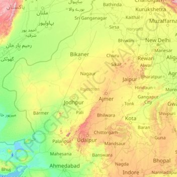
Nombre: Mapa topográfico Rajastán, altitud, relieve.
Lugar: Rajastán, India (23.05866 69.48444 30.19825 78.27201)
Altitud media: 254 m
Altitud mínima: -5 m
Altitud máxima: 2,299 m
Haz una donación
Otros mapas topográficos
Haga clic en un mapa para ver su topografía, su altitud y su relieve.
Ahmedabad
Ahmedabad se localiza en la India occidental, a una altitud de 53 m sobre el nivel medio del mar. Se localiza al margen del río Sabarmati, en la región central-norte del estado. Cubre una superficie de 205 km². El Sabarmati secciona la ciudad en dos, una parte oriental y la otra occidental. El río se seca…
Altitud media: 50 m
Haz una donación
Muzaffarpur
Se encuentra a una altitud de 58 m s. n. m. a 74 km de la capital estatal, Patna, en la zona horaria UTC +5:30.
Altitud media: 54 m
Haz una donación
Gandhinagar
India > Guyarat > Gandhinagar Taluka
Gandhinagar tiene una elevación promedio de 81 metros. La ciudad se encuentra en las orillas del río Sabarmati. Los 20 543 km² alrededor de Gandhinagar se define por tramos en el territorio guyaratí. Tiene un área de 205 km² (79.15 millas cuadradas). El río se seca con frecuencia en el verano, dejando…
Altitud media: 75 m
માંડવી
India > Guyarat > Mandvi Taluka
Se encuentra a una altitud de 7 m s. n. m. a 400 km de la capital estatal, Gandhinagar, en la zona horaria UTC +5:30.
Altitud media: 6 m
Haz una donación
Bombay
Bombay se encuentra en la costa del mar Arábigo en el oeste de la India. La altitud media de la ciudad es de 11 m sobre el nivel del mar.
Altitud media: 13 m
Haz una donación
Haz una donación
Haz una donación
Gaya
India > Bihar > Gaya Town C.D.Block
Se encuentra a una altitud de 121 m s. n. m. a 102 km de la capital estatal, Patna, en la zona horaria UTC +5:30.
Altitud media: 111 m
Haz una donación
Raja Sansi
India > Panyab > Ajnala Tahsil
Se encuentra a una altitud de 231 m s. n. m. a 247 km de la capital estatal, Chandigarh, en la zona horaria UTC +5:30.
Altitud media: 230 m
Thiruvananthapuram
India > Kerala > Thiruvananthapuram
Thiruvananthapuram está construida sobre colinas en la orilla del mar Arábigo en la costa oeste, cerca de la punta sur de India. La ciudad y los suburbios cubren un área de unos 250 km², insertada entre los Ghats occidentales. A una altitud media de 5 m s. n. m.
Altitud media: 33 m
Haz una donación
Muzaffarpur
Se encuentra a una altitud de 58 m s. n. m. a 74 km de la capital estatal, Patna, en la zona horaria UTC +5:30.
Altitud media: 54 m
Haz una donación
Nellore
India > Andhra Pradesh > Nellore
Se encuentra a una altitud de 32 m s. n. m. a 456 km de la capital estatal, Hyderabad, en la zona horaria UTC +5:30.
Altitud media: 17 m
Haz una donación
Haz una donación
Sohra (Cherrapunji)
India > Megalaya > Shella Bholaganj
Se encuentra a una altitud de 1498 m s. n. m. a 51 km de la capital estatal, Shillong, en la zona horaria UTC +5:30.
Altitud media: 1,169 m
Haz una donación
Beas
India > Panyab > Batala Tahsil
El río nace en el paso Rohtang, a una altitud de 3960 m en el estado de Himachal Pradesh, y se junta con el río Sutlej en Harike Pattan, al sur de Amritsar (en Panyab, India). El Sutlej sigue en el Punyab pakistaní y se une al río Chenab para formar el río Panchanad; que se une luego al río Indo en Mithankot.
Altitud media: 254 m
Haz una donación
Haz una donación
Haz una donación
Haz una donación
Leh
Leh fue la antigua capital del reino de Ladakh en los himalayas. Actualmente lo es del distrito de Leh y del territorio de Ladakh, India. En el pueblo aún se destacan las ruinas del palacio de Leh, dicho palacio era la residencia de la familia real de Ladakh, que es similar a una copia reducida del palacio…
Altitud media: 3,653 m
Haz una donación
Haz una donación
Haz una donación
Haz una donación
Memari
India > Bengala Occidental > Memari - I
Se encuentra a una altitud de 26 m s. n. m. a 89 km de la capital estatal, Calcuta, en la zona horaria UTC +5:30.
Altitud media: 21 m
Haz una donación
Haz una donación
Modasa
India > Guyarat > Modasa Taluka
Se encuentra a una altitud de 142 m s. n. m. a 105 km de la capital estatal, Gandhinagar, en la zona horaria UTC +5:30.
Altitud media: 149 m
Haz una donación
Ahmedabad
Ahmedabad se localiza en la India occidental, a una altitud de 53 m sobre el nivel medio del mar. Se localiza al margen del río Sabarmati, en la región central-norte del estado. Cubre una superficie de 205 km². El Sabarmati secciona la ciudad en dos, una parte oriental y la otra occidental. El río se seca…
Altitud media: 50 m
Leh
Leh fue la antigua capital del reino de Ladakh en los himalayas. Actualmente lo es del distrito de Leh y del territorio de Ladakh, India. En el pueblo aún se destacan las ruinas del palacio de Leh, dicho palacio era la residencia de la familia real de Ladakh, que es similar a una copia reducida del palacio…
Altitud media: 4,294 m
Haz una donación
Haz una donación