Geolocalizar

Mapa topográfico Lubbock

Mapa interactivo

Haga clic en el mapa para ver la altitud.

Acerca de este mapa

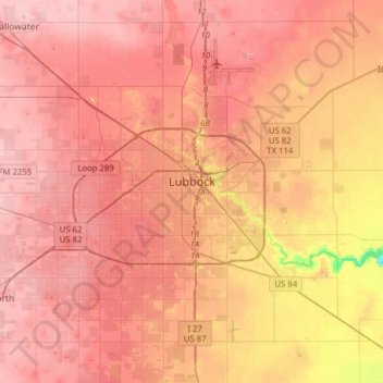
Nombre: Mapa topográfico Lubbock, altitud, relieve.

Lugar: Lubbock, Lubbock County, Texas, United States (33.44786 -102.03212 33.70843 -101.74901)

Altitud media: 983 m

Altitud mínima: 902 m

Altitud máxima: 1,015 m

Summers are hot, with 78 afternoons on average of 90 °F (32.2 °C)+ highs and 7.4 afternoons of 100 °F (37.8 °C)+ highs, although due to the aridity and elevation, temperatures remain above 70 °F (21.1 °C) on only a few mornings. Lubbock is the 10th-windiest city in the US with an average wind speed of 12.4 mph (20.0 km/h; 5.5 m/s). The highest recorded temperature was 114 °F (45.6 °C) on June 27, 1994.

Wikipedia (CC-BY-SA 3.0)

Otros mapas topográficos

Haga clic en un mapa para ver su topografía, su altitud y su relieve.

Lubbock

United States > Texas > Lubbock County

Lubbock, Lubbock County, Texas, United States

Altitud media: 988 m