
Mapa topográfico Ashland
Mapa interactivo
Haga clic en el mapa para ver la altitud.
Acerca de este mapa
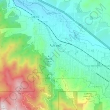
Nombre: Mapa topográfico Ashland, altitud, relieve.
Lugar: Ashland, Jackson County, Oregon, United States (42.16720 -122.73599 42.21605 -122.65110)
Altitud media: 774 m
Altitud mínima: 503 m
Altitud máxima: 1,477 m
Ashland lies within Oregon's southwest interior climate zone, in which all but the higher-elevation sites are in the rain shadow of the Oregon Coast Range to the west. The largest urban areas in this zone in addition to Ashland are Medford and Grants Pass in the Rogue Valley, and Roseburg in the Umpqua River Valley further north. Although the mountain peaks in this zone receive up to 120 inches or 3,050 millimetres of precipitation a year, the urban areas and the valleys in which they lie generally get 20 inches (510 mm) or less. This valley climate is particularly good for growing fruit, especially pears, and for producing other crops and farm goods such as hay, grain, poultry, and beef.
Otros mapas topográficos
Haga clic en un mapa para ver su topografía, su altitud y su relieve.
Trail
United States > Oregon > Jackson County
Trail, Jackson County, Oregon, 97539, United States
Altitud media: 534 m
Ruch
United States > Oregon > Jackson County
Ruch, Jackson County, Oregon, United States
Altitud media: 560 m
Applegate
United States > Oregon > Jackson County
Applegate, Jackson County, Oregon, United States
Altitud media: 501 m
Medford
United States > Oregon > Jackson County
Medford, Jackson County, Oregon, United States
Altitud media: 441 m
White City
United States > Oregon > Jackson County
White City, Jackson County, Oregon, 97503, United States
Altitud media: 404 m
Siskiyou Gap
United States > Oregon > Jackson County
Siskiyou Gap, Jackson County, Oregon, United States
Altitud media: 1,746 m
Fish Lake
United States > Oregon > Jackson County
Fish Lake, Jackson County, Oregon, United States
Altitud media: 1,456 m
Shady Cove
United States > Oregon > Jackson County
Shady Cove, Jackson County, Oregon, 97539, United States
Altitud media: 506 m
Eagle Point
United States > Oregon > Jackson County
Eagle Point, Jackson County, Oregon, 97524, United States
Altitud media: 422 m
Central Point
United States > Oregon > Jackson County
Central Point, Jackson County, Oregon, 97502, United States
Altitud media: 385 m
Lost Creek Lake
United States > Oregon > Jackson County
Lost Creek Lake, Jackson County, Oregon, United States
Altitud media: 729 m
Buncom
United States > Oregon > Jackson County
Buncom, Jackson County, Oregon, United States
Altitud media: 654 m
Mount Ashland
United States > Oregon > Jackson County
Mount Ashland, Jackson County, Oregon, United States
Altitud media: 1,957 m
Rogue River
United States > Oregon > Jackson County
Rogue River, Jackson County, Oregon, 97537, United States
Altitud media: 362 m
Phoenix
United States > Oregon > Jackson County
Phoenix, Jackson County, Oregon, 97535, United States
Altitud media: 469 m
Wagner Butte
United States > Oregon > Jackson County
Wagner Butte, Jackson County, Oregon, United States
Altitud media: 1,848 m
Gold Hill
United States > Oregon > Jackson County
Gold Hill, Jackson County, Oregon, United States
Altitud media: 416 m
Talent
United States > Oregon > Jackson County
Talent, Jackson County, Oregon, United States
Altitud media: 516 m
Jacksonville
United States > Oregon > Jackson County
Jacksonville, Jackson County, Oregon, 97530, United States
Altitud media: 522 m