
Mapa topográfico Tobacco Lake
Mapa interactivo
Haga clic en el mapa para ver la altitud.
Acerca de este mapa
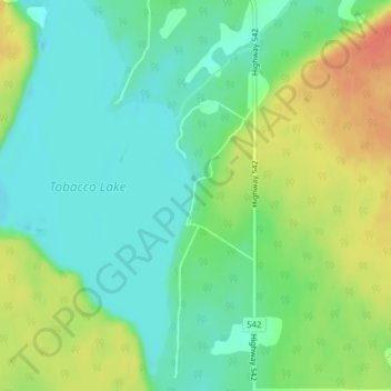
Nombre: Mapa topográfico Tobacco Lake, altitud, relieve.
Altitud media: 238 m
Altitud mínima: 219 m
Altitud máxima: 267 m
Otros mapas topográficos
Haga clic en un mapa para ver su topografía, su altitud y su relieve.
Barrie Island
Canada > Ontario > Gordon/Barrie Island
Barrie Island, Gordon/Barrie Island, Manitoulin District, Northeastern Ontario, Ontario, Canada
Altitud media: 189 m
Ice Lake
Canada > Ontario > Gordon/Barrie Island
Ice Lake, Gordon/Barrie Island, Manitoulin District, Ontario, Canada
Altitud media: 234 m