
Haz una donación
Mapa topográfico Battersea Park
Haga clic en el mapa para ver la altitud.
Haz una donación
Acerca de este mapa
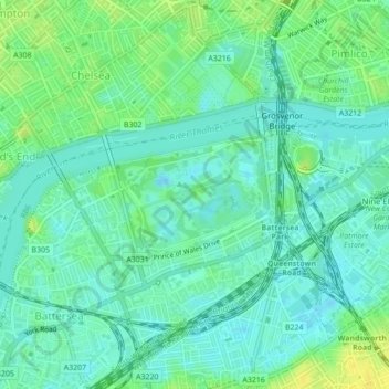
Nombre: Mapa topográfico Battersea Park, altitud, relieve.
Altitud media: 8 m
Altitud mínima: -1 m
Altitud máxima: 20 m
Haz una donación
Otros mapas topográficos
Haga clic en un mapa para ver su topografía, su altitud y su relieve.
Richmond
United Kingdom > England > London
The town centre lies just below 33 ft (10m) above sea level. South of the town centre, rising from Richmond Bridge to an elevation of 165 ft (50m), is Richmond Hill. Just beyond the summit of Richmond Hill is Richmond Park, an area of 2,360 acres (9.55 km2; 3.7 sq mi) of wild heath and woodland originally…
Altitud media: 17 m
Haz una donación
Wimbledon Common
United Kingdom > England > London
Putney Heath is around 160 hectares (400 acres) in size and sits at approximately 45 metres (148 feet) above sea level. Because of its elevation, from 1796 to 1816 Putney Heath hosted a station in the shutter telegraph chain, which connected the Admiralty in London to its naval ships in Portsmouth. This was…
Altitud media: 35 m
Haz una donación
Horsenden Hill
United Kingdom > England > London
The base of this isolated hill is at an altitude of approximately 50 metres. Like all of the immediately surrounding area, the base of the hill, as well as the slopes of the hill up to about 70m, are on London Clay. Between about 70m and 80m is an isolated layer of sandier Claygate Beds. Both deposits are of…
Altitud media: 40 m
Haz una donación
Haz una donación
Haz una donación
Haz una donación
Haz una donación
Haz una donación
River Brent
United Kingdom > England > London
The catchment area varies in altitude from just over 150 metres above sea level at Bushey Heath, on its northern watershed, to barely 10 metres at the confluence of the Brent with the Thames at Brentford.
Altitud media: 36 m
Haz una donación
Haz una donación
Haz una donación
Haz una donación
Haz una donación
Haz una donación
Haz una donación
Haz una donación
Haz una donación
Haz una donación
Haz una donación
Haz una donación
Haz una donación
Haz una donación