
Mapa topográfico Mountain Grove
Mapa interactivo
Haga clic en el mapa para ver la altitud.
Acerca de este mapa
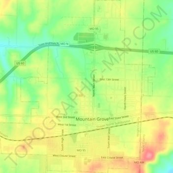
Nombre: Mapa topográfico Mountain Grove, altitud, relieve.
Altitud media: 444 m
Altitud mínima: 401 m
Altitud máxima: 488 m
This became known as the "mountain store, mountain grove or the mountain" due to its elevation of 1,525 feet (465 m). One of the most famous incidents in Mountain Grove occurred in the middle of May 1883, when what was called a "nipping frost" caused every tree, sapling and shrub in the community of Fyan and the Fyan depot to be cut clean as from an axe. Thus, the joining of Mountain Grove and adjoining Fyan occurred. In June, the name of the depot was changed to Mountain Grove. The town reapplied for a charter in 1886, changed its boundaries and held its first election.
Otros mapas topográficos
Haga clic en un mapa para ver su topografía, su altitud y su relieve.
Dawson
United States > Missouri > Wright County
Dawson, Wright County, Missouri, United States
Altitud media: 420 m
Saint George
United States > Missouri > Wright County
Saint George, Wright County, Missouri, United States
Altitud media: 392 m
Mansfield
United States > Missouri > Wright County
Mansfield, Wright County, Missouri, United States
Altitud media: 439 m
Norwood
United States > Missouri > Wright County
Norwood, Wright County, Missouri, United States
Altitud media: 447 m
Mountain Grove
United States > Missouri > Wright County > Mountain Grove > Mountain Grove
Mountain Grove, Wright County, Missouri, 65711, United States
Altitud media: 436 m
Macomb
United States > Missouri > Wright County
Macomb, Wright County, Missouri, 65702, United States
Altitud media: 440 m
Hartville
United States > Missouri > Wright County
Hartville, Wright County, Missouri, United States
Altitud media: 376 m
Cedar Gap
United States > Missouri > Wright County
Cedar Gap, Wright County, Missouri, United States
Altitud media: 474 m