
Mapa topográfico Estill County
Mapa interactivo
Haga clic en el mapa para ver la altitud.
Acerca de este mapa
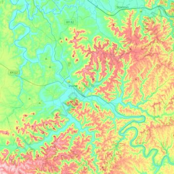
Nombre: Mapa topográfico Estill County, altitud, relieve.
Lugar: Estill County, Kentucky, United States (37.54319 -84.12708 37.85291 -83.72247)
Altitud media: 283 m
Altitud mínima: 174 m
Altitud máxima: 477 m
Estill County contains two important rivers. With the Red River, famous for its gorge in neighboring Powell County, forming the northern border. And the Kentucky River bisecting the county. Much of Estill County's development, including the towns of Irvine and Ravenna, is located in the fertile bottomlands of the Kentucky River. Additionally, due to the Kentucky River's deep valley and Estill County's location at the edge of the Cumberland plateau the county's topography is striking. The Pottsville Escarpment is prominent in the county, marking the divide between the Bluegrass and the mountains. Because of this topography total relief is nearly 1000 feet in the county, with the highest point being Zion Mountain, located about 6+1⁄2 miles southwest of Irvine at 1,511 feet, and the lowest point being the confluence of the Kentucky River and the Red River at 566 feet. Other high points include Happy Top Mountain, 1,500 feet; Preacher Estes Mountain, 1,475 feet; Peter Mountain, 1,454 feet; Low Knob, 1,450 feet; and Big Round Mountain, Buzzard Roost, and McKinney Mountain, each at 1,420 feet. [1]
Otros mapas topográficos
Haga clic en un mapa para ver su topografía, su altitud y su relieve.
Louisville
United States > Kentucky > Jefferson County
Louisville, Jefferson County, Kentucky, United States
Altitud media: 188 m
Somerset
United States > Kentucky > Pulaski County
Somerset, Pulaski County, Kentucky, 42503, United States
Altitud media: 295 m
Bowling Green
United States > Kentucky > Warren County
Bowling Green, Warren County, Kentucky, 42101, United States
Altitud media: 169 m
Paducah
United States > Kentucky > McCracken County
Paducah, McCracken County, Kentucky, United States
Altitud media: 108 m
Danville
United States > Kentucky > Boyle County
Danville, Boyle County, Kentucky, United States
Altitud media: 290 m
Frankfort
United States > Kentucky > Franklin County
Frankfort, Franklin County, Kentucky, United States
Altitud media: 216 m
Owensboro
United States > Kentucky > Daviess County
Owensboro, Daviess County, Kentucky, United States
Altitud media: 123 m
Newport
United States > Kentucky > Campbell County
Newport, Campbell County, Kentucky, 41071, United States
Altitud media: 173 m
Paint Lick
United States > Kentucky > Garrard County
Paint Lick, Garrard County, Kentucky, 40461, United States
Altitud media: 272 m
Lenarue
United States > Kentucky > Harlan County
Lenarue, Harlan County, Kentucky, 40818, United States
Altitud media: 519 m
Pathfork
United States > Kentucky > Harlan County
Pathfork, Harlan County, Kentucky, 40863, United States
Altitud media: 534 m
Hustonville
United States > Kentucky > Lincoln County
Hustonville, Lincoln County, Kentucky, United States
Altitud media: 316 m
Lone Star
United States > Kentucky > Hart County
Lone Star, Hart County, Kentucky, 42713, United States
Altitud media: 228 m
Sonora
United States > Kentucky > Hardin County
Sonora, Hardin County, Kentucky, United States
Altitud media: 221 m
Load
United States > Kentucky > Greenup County
Load, Greenup County, Kentucky, United States
Altitud media: 222 m
Bardo
United States > Kentucky > Harlan County
Bardo, Harlan County, Kentucky, 40830, United States
Altitud media: 634 m
Holmes Mill
United States > Kentucky > Harlan County
Holmes Mill, Harlan County, Kentucky, 40843, United States
Altitud media: 758 m
Pansy
United States > Kentucky > Harlan County
Pansy, Harlan County, Kentucky, 40830, United States
Altitud media: 602 m
Boyd
United States > Kentucky > Harrison County
Boyd, Harrison County, Kentucky, 41003, United States
Altitud media: 214 m
Uno
United States > Kentucky > Hart County
Uno, Hart County, Kentucky, United States
Altitud media: 201 m
Walnut Hill
United States > Kentucky > Fayette County > Lexington
Walnut Hill, Lexington, Fayette County, Kentucky, 40509, United States
Altitud media: 311 m
Sparrow
United States > Kentucky > Anderson County
Sparrow, Anderson County, Kentucky, United States
Altitud media: 230 m
Putney
United States > Kentucky > Harlan County
Putney, Harlan County, Kentucky, 40865, United States
Altitud media: 601 m
Inez
United States > Kentucky > Martin County
Inez, Martin County, Kentucky, 41224, United States
Altitud media: 253 m
Elkhorn City
United States > Kentucky > Pike County
Elkhorn City, Pike County, Kentucky, United States
Altitud media: 364 m
Alva
United States > Kentucky > Harlan County
Alva, Harlan County, Kentucky, 40863, United States
Altitud media: 652 m
Leesburg
United States > Kentucky > Harrison County
Leesburg, Harrison County, Kentucky, United States
Altitud media: 280 m
Hardyville
United States > Kentucky > Hart County
Hardyville, Hart County, Kentucky, United States
Altitud media: 212 m
Jonesville
United States > Kentucky > Hart County
Jonesville, Hart County, Kentucky, 42757, United States
Altitud media: 241 m
Frost
United States > Kentucky > Greenup County
Frost, Greenup County, Kentucky, 41175, United States
Altitud media: 180 m
Fresh Meadows
United States > Kentucky > Harlan County
Fresh Meadows, Harlan County, Kentucky, 40824, United States
Altitud media: 462 m
Pine Mountain
United States > Kentucky > Harlan County
Pine Mountain, Harlan County, Kentucky, United States
Altitud media: 536 m
Kenvir
United States > Kentucky > Harlan County
Kenvir, Harlan County, Kentucky, 40847, United States
Altitud media: 642 m
Ages
United States > Kentucky > Harlan County
Ages, Harlan County, Kentucky, 40801, United States
Altitud media: 587 m
Saint John
United States > Kentucky > Hardin County
Saint John, Hardin County, Kentucky, 42724, United States
Altitud media: 237 m
Nolin
United States > Kentucky > Hardin County
Nolin, Hardin County, Kentucky, 42740, United States
Altitud media: 210 m
Wallins Creek
United States > Kentucky > Harlan County
Wallins Creek, Harlan County, Kentucky, United States
Altitud media: 416 m
Lejunior
United States > Kentucky > Harlan County
Lejunior, Harlan County, Kentucky, 40865, United States
Altitud media: 585 m
Three Point
United States > Kentucky > Harlan County
Three Point, Harlan County, Kentucky, 40815, United States
Altitud media: 475 m
Louellen
United States > Kentucky > Harlan County
Louellen, Harlan County, Kentucky, 40849, United States
Altitud media: 698 m
Broadwell
United States > Kentucky > Harrison County
Broadwell, Harrison County, Kentucky, United States
Altitud media: 264 m
Hartford
United States > Kentucky > Ohio County
Hartford, Ohio County, Kentucky, United States
Altitud media: 123 m
Yancey
United States > Kentucky > Harlan County
Yancey, Harlan County, Kentucky, 40830, United States
Altitud media: 651 m
Wolf
United States > Kentucky > Carter County
Wolf, Carter County, Kentucky, United States
Altitud media: 271 m
Howe Valley
United States > Kentucky > Hardin County
Howe Valley, Hardin County, Kentucky, United States
Altitud media: 221 m
Hardin Springs
United States > Kentucky > Hardin County
Hardin Springs, Hardin County, Kentucky, 40145, United States
Altitud media: 195 m
Big Laurel
United States > Kentucky > Harlan County
Big Laurel, Harlan County, Kentucky, 40808, United States
Altitud media: 574 m
Limp
United States > Kentucky > Hardin County
Limp, Hardin County, Kentucky, United States
Altitud media: 211 m
Cawood
United States > Kentucky > Harlan County
Cawood, Harlan County, Kentucky, 40818, United States
Altitud media: 498 m