
Mapa topográfico Murtijapur
Mapa interactivo
Haga clic en el mapa para ver la altitud.
Murtijapur
Murtizapur is located at an average elevation of 308 metres (1210 feet). It is an important railway junction station in Akola district and is under Bhusawal-Badnera Section of Bhusawal Division of Central Railway.
Acerca de este mapa
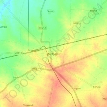
Nombre: Mapa topográfico Murtijapur, altitud, relieve.
Lugar: Murtijapur, Akola, Maharashtra, 444107, India (20.69465 77.32993 20.77465 77.40993)
Altitud media: 300 m
Altitud mínima: 274 m
Altitud máxima: 323 m
Otros mapas topográficos
Haga clic en un mapa para ver su topografía, su altitud y su relieve.
Murtijapur
India > Maharashtra > Murtijapur
Murtizapur is located at an average elevation of 308 metres (1210 feet). It is an important railway junction station in Akola district and is under Bhusawal-Badnera Section of Bhusawal Division of Central Railway.
Altitud media: 308 m