
Mapa topográfico Chichester
Mapa interactivo
Haga clic en el mapa para ver la altitud.
Acerca de este mapa
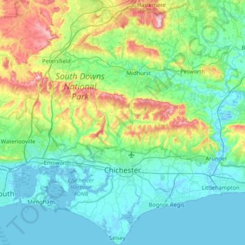
Nombre: Mapa topográfico Chichester, altitud, relieve.
Lugar: Chichester, West Sussex, England, United Kingdom (50.72178 -0.95760 51.09449 -0.47318)
Altitud media: 57 m
Altitud mínima: -4 m
Altitud máxima: 279 m
Otros mapas topográficos
Haga clic en un mapa para ver su topografía, su altitud y su relieve.
Blackdown
United Kingdom > England > West Sussex > Chichester
Blackdown, or Black Down, summit elevation 279.7 metres (918 ft) AMSL, is the highest point in both the historic county of Sussex and the South Downs National Park. It is one of the highest points in the south east of England, exceeded by Walbury Hill, Leith Hill and Pilot Hill. Blackdown is protected as part…
Altitud media: 165 m
Washington Common
United Kingdom > England > West Sussex > Storrington > Washington
Altitud media: 61 m
Henry Burt Wood
United Kingdom > England > West Sussex > Mid Sussex > Burgess Hill
Altitud media: 39 m
Smock Alley
United Kingdom > England > West Sussex > Horsham > West Chiltington Common
Altitud media: 38 m
Blackdown
United Kingdom > England > West Sussex > Chichester
Blackdown, or Black Down, summit elevation 279.7 metres (918 ft) AMSL, is the highest point in both the historic county of Sussex and the South Downs National Park. It is one of the highest points in the south east of England, exceeded by Walbury Hill, Leith Hill and Pilot Hill. Blackdown is protected as part…
Altitud media: 165 m
Westerton
United Kingdom > England > West Sussex > Chichester > Westhampnett > Westerton
Altitud media: 30 m
Batchelors Farm Nature Conservation Site
United Kingdom > England > West Sussex > Mid Sussex District > Burgess Hill
Altitud media: 49 m
Brook Street
United Kingdom > England > West Sussex > Mid Sussex > Whitemans Green
Altitud media: 76 m