
Haz una donación
Mapa topográfico Chhindwara
Haga clic en el mapa para ver la altitud.
Haz una donación
Chhindwara
The altitude of the district varies from 1,550 ft (470 m) to 3,820 ft (1,160 m) above sea level with an average elevation of 2215 feet (675 m).
Haz una donación
Acerca de este mapa
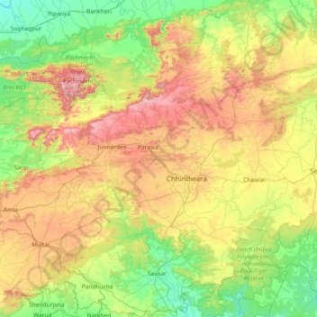
Nombre: Mapa topográfico Chhindwara, altitud, relieve.
Lugar: Chhindwara, Madhya Pradesh, India (21.59757 78.24496 22.81688 79.40653)
Altitud media: 619 m
Altitud mínima: 308 m
Altitud máxima: 1,294 m
Haz una donación
Otros mapas topográficos
Haga clic en un mapa para ver su topografía, su altitud y su relieve.
Bhopal
India > Madhya Pradesh > Huzur Tahsil
Bhopal has an average elevation of 500 metres (1401 ft) and is located in the central part of India, just north of the upper limit of the Vindhya mountain ranges. Located on the Malwa plateau, it is higher than the north Indian plains and the land rises towards the Vindhya Range to the south. The city has…
Altitud media: 498 m
Indore
India > Madhya Pradesh > Juni Indore Tahsil
Indore /ɪnˈdɔːr/ (listen) is the most populous and the largest city in the Indian state of Madhya Pradesh. It serves as the headquarters of both Indore District and Indore Division. It is also considered as an education hub of the state and has campuses of both the Indian Institute of Technology and the…
Altitud media: 555 m
Gwalior
India > Madhya Pradesh > Gird Tahsil
Gwalior is located at 26°13′N 78°11′E / 26.22°N 78.18°E / 26.22; 78.18. in northern Madhya Pradesh 300 km (186 miles) from Delhi. It has an average elevation of 197 metres (646 feet). Most part of it comes under the Bundelkhand area.
Altitud media: 235 m
Haz una donación
Chanderi
India > Madhya Pradesh > Chanderi Tahsil
Chanderi is located at 24°43′N 78°08′E / 24.72°N 78.13°E / 24.72; 78.13. It has an average elevation of 456 metres (1496 feet).
Altitud media: 440 m
Haz una donación
Jirapur
India > Madhya Pradesh > Jirapur Tahsil
Jirapur Tehsil is bounded by Khilchipur Tehsil towards east, Nalkheda Tehsil towards south, Susner Tehsil towards west, Bakani Tehsil towards the north. Sarangpur City, Shajapur City, Pachore City, Jhalawar City are the nearby Cities to Jirapur. This city is near on MP and Rajasthan border. Jirapur consists of…
Altitud media: 396 m
Haz una donación
Haz una donación
Ujjain
India > Madhya Pradesh > Ujjain NagarTahsil
Ujjain is located in the west-central part of India, and is north of the upper limit of the Vindhya mountain ranges. Located on the Malwa plateau, it is higher than the north Indian plains and the land rises towards the Vindhya Range to the south. Ujjain's co-ordinates are 23°10′N 75°46′E /…
Altitud media: 501 m
Haz una donación
Ujjain
India > Madhya Pradesh > Ujjain NagarTahsil
Ujjain is located in the west-central part of India, and is north of the upper limit of the Vindhya mountain ranges. Located on the Malwa plateau, it is higher than the north Indian plains and the land rises towards the Vindhya Range to the south. Ujjain's coordinates are 23°10′N 75°46′E /…
Altitud media: 501 m
Haz una donación
Manpur
India > Madhya Pradesh > Mhow Tahsil
Manpur is located at 22°26′N 75°37′E / 22.43°N 75.62°E / 22.43; 75.62. It has an average elevation of 567 metres (1860 feet).
Altitud media: 574 m
Haz una donación
Haz una donación
Haz una donación
Khandwa
India > Madhya Pradesh > Khandwa Nagar Tahsil
Khandwa is located at 21°50′N 76°20′E / 21.83°N 76.33°E / 21.83; 76.33. It has an average elevation of 313 metres (1026 feet).
Altitud media: 325 m
Haz una donación
Haz una donación
Haz una donación
Haz una donación
Khandwa
India > Madhya Pradesh > Khandwa Nagar Tahsil
Khandwa is located at 21°50′N 76°20′E / 21.83°N 76.33°E / 21.83; 76.33. It has an average elevation of 313 metres (1026 feet).
Altitud media: 325 m
Ujjain
India > Madhya Pradesh > Ujjain NagarTahsil
Ujjain is located in the west-central part of India, and is north of the upper limit of the Vindhya mountain ranges. Located on the Malwa plateau, it is higher than the north Indian plains and the land rises towards the Vindhya Range to the south. Ujjain's coordinates are 23°10′N 75°46′E /…
Altitud media: 501 m
Haz una donación
Haz una donación
Haz una donación
Haz una donación
Pachmarhi
India > Madhya Pradesh > Pipariya Tahsil
Pachmarhi has an altitude of 1,067 meters above sea level. Dhupgarh, the highest point (1,352 meters) in Madhya Pradesh and the Satpura range, is located nearby. The town is wholly located within the Pachmarhi Biosphere Reserve and the Satpura Tiger Reserve.
Altitud media: 968 m
Haz una donación
Haz una donación
Bhopal
India > Madhya Pradesh > Huzur Tahsil
Bhopal has an average elevation of 500 metres (1401 ft) and is located in the central part of India, just north of the upper limit of the Vindhya mountain ranges. Located on the Malwa plateau, it is higher than the north Indian plains and the land rises towards the Vindhya Range to the south. The city has…
Altitud media: 498 m
Haz una donación
Haz una donación
Haz una donación
Haz una donación
Haz una donación
Khandwa
India > Madhya Pradesh > Khandwa Nagar Tahsil
Khandwa is located at 21°50′N 76°20′E / 21.83°N 76.33°E / 21.83; 76.33. It has an average elevation of 313 metres (1026 feet).
Altitud media: 325 m
Haz una donación