
Mapa topográfico Portola Valley
Mapa interactivo
Haga clic en el mapa para ver la altitud.
Acerca de este mapa
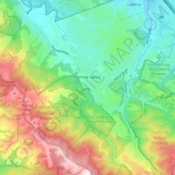
Nombre: Mapa topográfico Portola Valley, altitud, relieve.
Altitud media: 287 m
Altitud mínima: 78 m
Altitud máxima: 661 m
Otros mapas topográficos
Haga clic en un mapa para ver su topografía, su altitud y su relieve.
Highlands
United States > California > San Mateo County > San Mateo Highlands > Highlands
Altitud media: 129 m
San Carlos
United States > California > San Mateo County > San Carlos > San Carlos
Altitud media: 47 m
Daly City
United States > California > San Mateo County > Daly City
Several golf courses are located within or straddle the border with San Francisco. The Olympic Club has hosted the USGA U.S. Open five times, most recently in 2012, and will host both the 2028 PGA Championship and the 2032 Ryder Cup. The private San Francisco Golf Club and Lake Merced Golf Club have part or…
Altitud media: 32 m
Half Moon Bay
United States > California > San Mateo County > Half Moon Bay > Half Moon Bay
Altitud media: 73 m