
Haz una donación
Mapa topográfico Chipping Barnet
Haga clic en el mapa para ver la altitud.
Haz una donación
Chipping Barnet
Its name is very often abbreviated to just Barnet, which is also the name of the borough of which it forms a part; the town has been part of Greater London since 1965 after the abolition of Barnet Urban District then in Hertfordshire. Chipping Barnet is also the name of the Parliamentary constituency covering the local area – the word "Chipping" denotes the presence of a market, one that was established here at the end of the 12th century and persists to this day. Chipping Barnet is one of the highest urban settlements in London, with the town centre having an elevation of about 427 feet (130 m).
Haz una donación
Acerca de este mapa
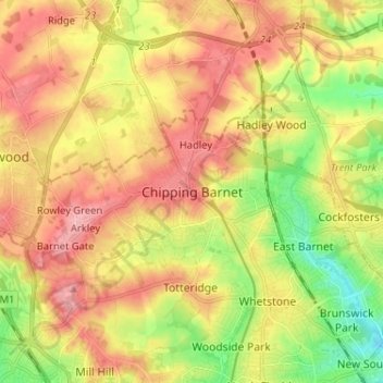
Nombre: Mapa topográfico Chipping Barnet, altitud, relieve.
Altitud media: 95 m
Altitud mínima: 36 m
Altitud máxima: 147 m
Haz una donación
Otros mapas topográficos
Haga clic en un mapa para ver su topografía, su altitud y su relieve.
Haz una donación
Haz una donación
Haz una donación
Haz una donación
Haz una donación
Haz una donación
Norwood Grove
United Kingdom > England > Greater London
After Anderson died, ownership passed to the Nettlefold family and subsequently to Frederick Nettlefold the brother of Joseph Nettlefold and a member of the family that founded the Nettlefolds Ltd. engineering firm which later became GKN. Nettlefold is commemorated, as a result of his charitable works, by a…
Altitud media: 58 m
Haz una donación
Haz una donación
Haz una donación