
Mapa topográfico Airedale
Mapa interactivo
Haga clic en el mapa para ver la altitud.
Acerca de este mapa
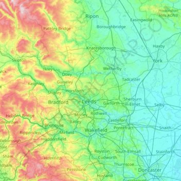
Nombre: Mapa topográfico Airedale, altitud, relieve.
Altitud media: 136 m
Altitud mínima: -1 m
Altitud máxima: 702 m
This valley is of great topographic significance as it provides low-altitude passes through the mid Pennines to the west coast known as the Aire Gap.
Otros mapas topográficos
Haga clic en un mapa para ver su topografía, su altitud y su relieve.
Rawcliffe
United Kingdom > England > York
Rawcliffe, York, Yorkshire and the Humber, England, United Kingdom
Altitud media: 14 m
Hogg's Pond
United Kingdom > England > York
Hogg's Pond, Chaloners Road, Woodthorpe, York, Yorkshire and the Humber, England, YO24 2TW, United Kingdom
Altitud media: 14 m
Stock Hill
United Kingdom > England > York
Stock Hill, York, Yorkshire and the Humber, England, YO23 3PW, United Kingdom
Altitud media: 28 m