Mapa topográfico Jammu
Mapa interactivo
Haga clic en el mapa para ver la altitud.
Acerca de este mapa
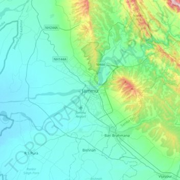
Nombre: Mapa topográfico Jammu, altitud, relieve.
Lugar: Jammu, Jammu District, Jammu and Kashmir, 180001, India (32.55856 74.69809 32.87856 75.01809)
Altitud media: 367 m
Altitud mínima: 255 m
Altitud máxima: 987 m
Jammu is located at 32°44′N 74°52′E / 32.73°N 74.87°E / 32.73; 74.87. It has an average elevation of 300 m (980 ft). Jammu city lies at uneven ridges of low heights at the Shivalik hills. It is surrounded by the Shivalik range to the north, east, and southeast while the Trikuta Range surrounds it in the northwest. It is approximately 600 kilometres (370 mi) from the national capital, New Delhi.
Otros mapas topográficos
Haga clic en un mapa para ver su topografía, su altitud y su relieve.
Jhajjar Nala
India > Jammu and Kashmir > Jammu > Domel
Jhajjar Nala, Domel, Jammu, Jammu district, Jammu and Kashmir, 181224, India
Altitud media: 559 m