
Mapa topográfico Kurnool
Mapa interactivo
Haga clic en el mapa para ver la altitud.
Acerca de este mapa
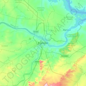
Nombre: Mapa topográfico Kurnool, altitud, relieve.
Lugar: Kurnool, Andhra Pradesh, 518001, India (15.67093 77.88254 15.99093 78.20254)
Altitud media: 307 m
Altitud mínima: 259 m
Altitud máxima: 453 m
Kurnool is located at 15°50′00″N 78°03′00″E / 15.8333°N 78.05°E / 15.8333; 78.05. It has an average elevation of 273 metres (898 feet). Kurnool lies on the banks of the Tungabhadra River. The Hundri and Neeva rivers also flow through the city. The K.C.Canal (Kurnool–Cuddapah) was built by the Dutch for transportation, but later used for irrigation.