
Mapa topográfico Bengaluru
Mapa interactivo
Haga clic en el mapa para ver la altitud.
Acerca de este mapa
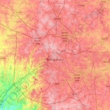
Nombre: Mapa topográfico Bengaluru, altitud, relieve.
Altitud media: 881 m
Altitud mínima: 722 m
Altitud máxima: 965 m
Bangalore (/bæŋɡəˈlɔːr/), officially Bengaluru (Kannada pronunciation: [ˈbeŋgɐɭuːɾu] (listen)), is the capital and largest city of the Indian state of Karnataka. It has a population of more than 8 million and a metropolitan population of around 11 million, making it the third most populous city and fifth most populous urban agglomeration in India, as well as the largest city in South India, and the 27th largest city in the world. Located on the Deccan Plateau, at a height of over 900 m (3,000 ft) above sea level, Bangalore has a pleasant climate throughout the year, with its parks and green spaces earning it the reputation as the "Garden City" of India. Its elevation is the highest among the major cities of India. An aerospace and electronics hub since the 1960s, Bangalore is widely regarded as the "Silicon Valley of India" because of its role as the nation's leading information technology (IT) exporter. In the Ease of Living Index 2020 (published by the Ministry of Housing and Urban Affairs), it was ranked the most livable Indian city with a population of over a million. It also ranks among the highest Indian cities in terms of global livability rankings as well.
Otros mapas topográficos
Haga clic en un mapa para ver su topografía, su altitud y su relieve.
Chikkabidarakallu
India > Karnataka > Bangalore North
Chikkabidarakallu, Bangalore North, Bengaluru Urban, Karnataka, 560073, India
Altitud media: 877 m
Dasanapura
India > Karnataka > Bangalore North
Dasanapura, Bangalore North, Bengaluru Urban District, Karnataka, 562162, India
Altitud media: 862 m
Shivaji Nagar Ward
India > Karnataka > Bangalore North > Bengaluru
Shivaji Nagar Ward, East Zone, Bengaluru, Bangalore North, Bengaluru Urban District, Karnataka, India
Altitud media: 916 m
Bangalore Palace
India > Karnataka > Bangalore North > Bengaluru
Bangalore Palace, Jayamahal Road, Sadhashivanagar, Aramane Nagara Ward, West Zone, Bengaluru, Bangalore North, Bengaluru Urban District, Karnataka, 560006, India
Altitud media: 927 m
Kodigehalli
India > Karnataka > Bangalore North > Bengaluru
Kodigehalli, Yelahanka Zone, Bengaluru, Bangalore North, Bengaluru Urban District, Karnataka, India, Hebbal Lake
Altitud media: 904 m
Rajarajeshwari Nagar Zone
India > Karnataka > Bangalore North > Bengaluru
Rajarajeshwari Nagar Zone, Bengaluru, Bangalore North, Bengaluru Urban District, Karnataka, Bengaluru Division, India
Altitud media: 857 m
T Dasarahalli
India > Karnataka > Bangalore North > Bengaluru
T Dasarahalli, Dasarahalli Zone, Bengaluru, Bangalore North, Bengaluru Urban District, Karnataka, India
Altitud media: 906 m
Bugle Rock Park
India > Karnataka > Bangalore North > Bengaluru
Bugle Rock Park, Basavanagudi Ward, South Zone, Bengaluru, Bangalore North, Bangalore Urban, Karnataka, India
Altitud media: 908 m
Banni Mantapa
India > Karnataka > Bangalore North > Bengaluru
Banni Mantapa, Katriguppe, South Zone, Bengaluru, Bangalore North, Bangalore Urban, Karnataka, India
Altitud media: 882 m
Cubbon Park
India > Karnataka > Bangalore North > Bengaluru
Cubbon Park, Sampangiram Nagar Ward, East Zone, Bengaluru, Bangalore North, Bangalore Urban, Karnataka, 560001, India
Altitud media: 917 m
Ulsoor Lake
India > Karnataka > Bangalore North > Bengaluru
Ulsoor Lake, Halasooru, East Zone, Bengaluru, Bangalore North, Bengaluru Urban District, Karnataka, India
Altitud media: 905 m
Nagawara Lake
India > Karnataka > Bangalore North > Bengaluru
Nagawara Lake, Byatarayanapura, Yelahanka Zone, Bengaluru, Bangalore North, Bangalore Urban, Karnataka, India
Altitud media: 896 m
Vijayanagar
India > Karnataka > Bangalore North > Bengaluru
Vijayanagar, South Zone, Bengaluru, Bangalore North, Bangalore Urban, Karnataka, India
Altitud media: 880 m
Soladevanahalli
India > Karnataka > Bangalore North
Soladevanahalli, Bangalore North, Bangalore Urban, Karnataka, 560090, India
Altitud media: 866 m
Rajanakunte
India > Karnataka > Bangalore North
Rajanakunte, Bangalore North, Bangalore Urban, Karnataka, 562157, India
Altitud media: 915 m
HRBR Layout
India > Karnataka > Bangalore North > Bengaluru
HRBR Layout, Kacharkanahalli, East Zone, Bengaluru, Bangalore North, Bangalore Urban, Karnataka, 540045, India
Altitud media: 895 m
Thirumenahalli
India > Karnataka > Bangalore North > Bengaluru > Thirumenahalli
Thirumenahalli, Bengaluru, Bangalore North, Bangalore Urban, Karnataka, 560063, India
Altitud media: 908 m
Sankey Tank
India > Karnataka > Bangalore North > Bengaluru
Sankey Tank, Aramane Nagara Ward, West Zone, Bengaluru, Bangalore North, Bengaluru Urban District, Karnataka, India
Altitud media: 931 m
Vasanth Nagar
India > Karnataka > Bangalore North > Bengaluru
Vasanth Nagar, East Zone, Bengaluru, Bangalore North, Bangalore Urban, Karnataka, 560052, India
Altitud media: 922 m
Vishvanathapura
India > Karnataka > Bangalore North > Vishvanathapura
Vishvanathapura, Bangalore North, Bangalore Urban, Karnataka, 562163, India
Altitud media: 900 m
Bagaluru
India > Karnataka > Bangalore North
Bagaluru, Bangalore North, Bangalore Urban, Karnataka, 562149, India
Altitud media: 899 m
Gangodanahalli
India > Karnataka > Bangalore North
Gangodanahalli, Bangalore North, Bangalore Urban, Karnataka, 560018, India
Altitud media: 865 m
Cottonpete
India > Karnataka > Bangalore North > Bengaluru
Cottonpete, West Zone, Bengaluru, Bangalore North, Bangalore Urban, Karnataka, India
Altitud media: 894 m