
Mapa topográfico Dilbeek
Mapa interactivo
Haga clic en el mapa para ver la altitud.
Acerca de este mapa
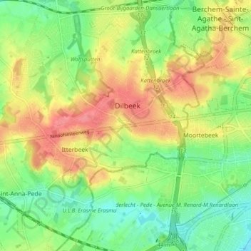
Nombre: Mapa topográfico Dilbeek, altitud, relieve.
Lugar: Dilbeek, Hal-Vilvorde, Brabant flamand, Flandre, 1700, Belgique (50.81989 4.22756 50.86846 4.28984)
Altitud media: 52 m
Altitud mínima: 20 m
Altitud máxima: 88 m
Otros mapas topográficos
Haga clic en un mapa para ver su topografía, su altitud y su relieve.
Chapelle-Saint-Ulric
Belgique > Brabant flamand > Hal-Vilvorde > Dilbeek
Chapelle-Saint-Ulric, Dilbeek, Hal-Vilvorde, Brabant flamand, Belgique
Altitud media: 49 m
Grand-Bigard
Belgique > Brabant flamand > Hal-Vilvorde > Dilbeek
Grand-Bigard, Dilbeek, Hal-Vilvorde, Brabant flamand, 1702, Belgique
Altitud media: 51 m
Itterbeek
Belgique > Brabant flamand > Hal-Vilvorde > Dilbeek
Itterbeek, Dilbeek, Hal-Vilvorde, Brabant flamand, Flandre, 1701, Belgique
Altitud media: 51 m
Schepdael
Belgique > Brabant flamand > Hal-Vilvorde > Dilbeek
Schepdael, Dilbeek, Hal-Vilvorde, Brabant flamand, Flandre, 1703, Belgique
Altitud media: 55 m