
Mapa topográfico Audubon Society
Mapa interactivo
Haga clic en el mapa para ver la altitud.
Acerca de este mapa
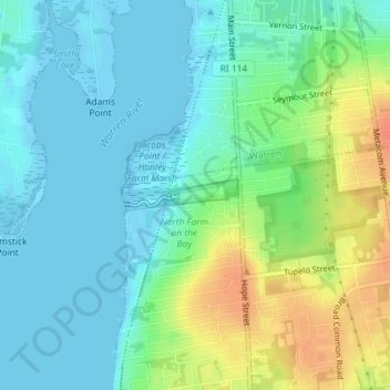
Nombre: Mapa topográfico Audubon Society, altitud, relieve.
Altitud media: 14 m
Altitud mínima: -6 m
Altitud máxima: 44 m
Otros mapas topográficos
Haga clic en un mapa para ver su topografía, su altitud y su relieve.
Snake Den
USA > Rhode Island > Johnston
Snake Den, Johnston, Providence, Rhode Island, 02919, USA
Altitud media: 90 m
Beavertail State Park
USA > Rhode Island > Jamestown
Beavertail State Park, Jamestown, Newport, Rhode Island, USA
Altitud media: 2 m
Ninigret National Wildlife Refuge
USA > Rhode Island > Charlestown
Ninigret National Wildlife Refuge, Charlestown, Washington, Rhode Island, USA
Altitud media: 1 m
Killingly Pond
USA > Rhode Island > Glocester
Killingly Pond, Dam Road, Glocester, Windham County, Rhode Island, 06243, USA
Altitud media: 193 m
Narragansett Bay National Estuarine Research Reserve
USA > Rhode Island > Portsmouth
Narragansett Bay National Estuarine Research Reserve, 55, Portsmouth, Newport, Rhode Island, 02872, USA
Altitud media: 10 m
Rhode Island Sound
USA > Rhode Island > Little Compton
Rhode Island Sound, Rhode Island Road, Little Compton, Newport, Rhode Island, 02837, USA
Altitud media: 0 m
Badger Mountain
USA > Rhode Island > Burrillville
Badger Mountain, Burrillville, Providence, Rhode Island, USA
Altitud media: 190 m
Norman Bird Sanctuary
USA > Rhode Island > Middletown
Norman Bird Sanctuary, Middletown, Newport, Rhode Island, 02842, USA
Altitud media: 16 m