
Mapa topográfico Running Springs
Mapa interactivo
Haga clic en el mapa para ver la altitud.
Acerca de este mapa
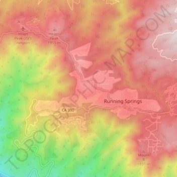
Nombre: Mapa topográfico Running Springs, altitud, relieve.
Altitud media: 1,656 m
Altitud mínima: 875 m
Altitud máxima: 2,157 m
Running Springs is a mountain community in the San Bernardino Mountains. It is an inholding in the San Bernardino National Forest. Situated at the junction of State Route 18 and State Route 330, it is a major gateway to the mountain communities of Lake Arrowhead, Arrowbear, Green Valley Lake, and Big Bear and is the closest community to Snow Valley Mountain Resort. It lies some 16 miles (26 km) northeast of the city of Highland, California, up State Route 330, at an elevation of 6,080 feet (1,850 m). While there is no primary industry in Running Springs, there are service industries geared to the tourism market, as the San Bernardino National Forest is a year-round tourist destination.
Otros mapas topográficos
Haga clic en un mapa para ver su topografía, su altitud y su relieve.
Fredalba
United States > California > San Bernardino County > Running Springs
Fredalba, Running Springs, San Bernardino County, CAL Fire Southern Region, California, 92382, United States
Altitud media: 1,547 m
Arrowbear Lake
United States > California > San Bernardino County > Running Springs
Arrowbear Lake, Running Springs, San Bernardino County, California, 92382, United States
Altitud media: 1,928 m