
Mapa topográfico Ranchi
Mapa interactivo
Haga clic en el mapa para ver la altitud.
Acerca de este mapa
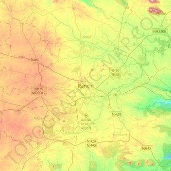
Nombre: Mapa topográfico Ranchi, altitud, relieve.
Lugar: Ranchi, Kanke, Ranchi District, Jharkhand, 834001, India (23.21005 85.16504 23.53005 85.48504)
Altitud media: 648 m
Altitud mínima: 458 m
Altitud máxima: 896 m
Ranchi lies at 23°22′N 85°20′E / 23.36°N 85.33°E / 23.36; 85.33 near to the Tropic of Cancer. The city covers an area of 175 km2 (68 sq mi) and its average elevation is 651 m above sea level. Ranchi is located in the southern part of the Chota Nagpur plateau, which is the eastern section of the Deccan plateau.
Otros mapas topográficos
Haga clic en un mapa para ver su topografía, su altitud y su relieve.
Rock Garden
India > Jharkhand > Kanke > Ranchi
Rock Garden, Pahar Gonda, Ranchi, Kanke, Ranchi, Jharkhand, India
Altitud media: 644 m