
Mapa topográfico Maharastra
Mapa interactivo
Haga clic en el mapa para ver la altitud.
Acerca de este mapa
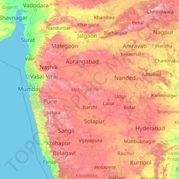
Nombre: Mapa topográfico Maharastra, altitud, relieve.
Lugar: Maharastra, India (15.60636 72.65261 22.03027 80.89778)
Altitud media: 346 m
Altitud mínima: -1 m
Altitud máxima: 1,418 m
Otros mapas topográficos
Haga clic en un mapa para ver su topografía, su altitud y su relieve.