
Mapa topográfico Spearfish
Mapa interactivo
Haga clic en el mapa para ver la altitud.
Acerca de este mapa
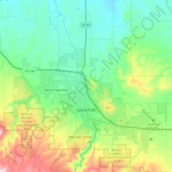
Nombre: Mapa topográfico Spearfish, altitud, relieve.
Lugar: Spearfish, Lawrence County, South Dakota, United States (44.45282 -103.90541 44.56661 -103.71413)
Altitud media: 1,171 m
Altitud mínima: 984 m
Altitud máxima: 1,643 m
Extreme winter maxima in the district are remarkably warm given the latitude and altitude; on January 19, 1921 Spearfish reached a temperature of 79 °F (26 °C), the hottest January temperature in South Dakota on record.
Otros mapas topográficos
Haga clic en un mapa para ver su topografía, su altitud y su relieve.
Savoy
United States > South Dakota > Lawrence County
Savoy, Lawrence County, South Dakota, United States
Altitud media: 1,665 m
Terry Peak
United States > South Dakota > Lawrence County
Terry Peak, Lawrence County, South Dakota, United States
Altitud media: 1,940 m
Deadwood
United States > South Dakota > Lawrence County
Deadwood, Lawrence County, South Dakota, 57732, United States
Altitud media: 1,511 m
Cheyenne Crossing
United States > South Dakota > Lawrence County
Cheyenne Crossing, Lawrence County, South Dakota, United States
Altitud media: 1,784 m
Bridal Veil Falls
United States > South Dakota > Lawrence County
Bridal Veil Falls, Lawrence County, South Dakota, United States
Altitud media: 1,502 m
Spearfish
United States > South Dakota > Lawrence County > Spearfish
Spearfish, Lawrence County, South Dakota, 57783, United States
Altitud media: 1,291 m
Lead
United States > South Dakota > Lawrence County
Lead, Lawrence County, South Dakota, United States
Altitud media: 1,605 m