
Mapa topográfico Clermont County
Mapa interactivo
Haga clic en el mapa para ver la altitud.
Acerca de este mapa
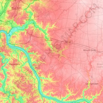
Nombre: Mapa topográfico Clermont County, altitud, relieve.
Lugar: Clermont County, Ohio, United States (38.77026 -84.32053 39.27080 -83.98990)
Altitud media: 247 m
Altitud mínima: 140 m
Altitud máxima: 315 m
Otros mapas topográficos
Haga clic en un mapa para ver su topografía, su altitud y su relieve.
Columbus
United States > Ohio > Franklin County > Columbus
The confluence of the Scioto and Olentangy rivers is just north-west of Downtown Columbus. Several smaller tributaries course through the Columbus metropolitan area, including Alum Creek, Big Walnut Creek, and Darby Creek. Columbus is considered to have relatively flat topography thanks to a large glacier that…
Altitud media: 255 m
French Park
United States > Ohio > Hamilton County > Amberley Village > Rolling Knolls Estate
Altitud media: 235 m
Cincinnati
United States > Ohio > Hamilton County
Cincinnati has several standard modes of transportation including sidewalks, roads, public transit, bicycle paths and airports. The city's hills preclude the regular street grid common to many cities built up in the 19th century, and outside of the downtown basin, regular street grids are rare except for in…
Altitud media: 225 m