
Mapa topográfico Wimbledon Park
Mapa interactivo
Haga clic en el mapa para ver la altitud.
Acerca de este mapa
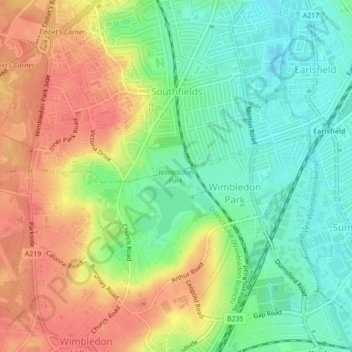
Nombre: Mapa topográfico Wimbledon Park, altitud, relieve.
Altitud media: 31 m
Altitud mínima: 4 m
Altitud máxima: 58 m
Otros mapas topográficos
Haga clic en un mapa para ver su topografía, su altitud y su relieve.
Richmond
United Kingdom > England > London
The town centre lies just below 33 ft (10m) above sea level. South of the town centre, rising from Richmond Bridge to an elevation of 165 ft (50m), is Richmond Hill. Just beyond the summit of Richmond Hill is Richmond Park, an area of 2,360 acres (9.55 km2; 3.7 sq mi) of wild heath and woodland originally…
Altitud media: 17 m
Wimbledon Common
United Kingdom > England > London
Putney Heath is around 160 hectares (400 acres) in size and sits at approximately 45 metres (148 feet) above sea level. Because of its elevation, from 1796 to 1816 Putney Heath hosted a station in the shutter telegraph chain, which connected the Admiralty in London to its naval ships in Portsmouth. This was…
Altitud media: 35 m
River Brent
United Kingdom > England > London
The catchment area varies in altitude from just over 150 metres above sea level at Bushey Heath, on its northern watershed, to barely 10 metres at the confluence of the Brent with the Thames at Brentford.
Altitud media: 36 m
London Borough of Croydon
United Kingdom > England > London
The most common householder type were owner occupied with only a small percentage rented. Many new housing schemes and developments are currently taking place in Croydon, such as The Exchange and Bridge House, IYLO, Wellesley Square (now known as Saffron Square) and Altitude 25. In 2006, The Metropolitan…
Altitud media: 102 m
London Borough of Bromley
United Kingdom > England > London
Westerham Heights, the highest point in London and Kent at an altitude of 804 feet (245 m), is on the southern boundary. The Prime Meridian passes through Bromley.
Altitud media: 104 m