
Mapa topográfico Bury St Edmunds
Mapa interactivo
Haga clic en el mapa para ver la altitud.
Acerca de este mapa
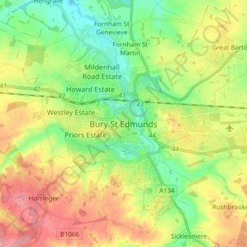
Nombre: Mapa topográfico Bury St Edmunds, altitud, relieve.
Altitud media: 59 m
Altitud mínima: 21 m
Altitud máxima: 107 m
The name Bury is etymologically connected with borough, which has cognates in other Germanic languages such as the German burg meaning "fortress, castle"; Old Norse borg meaning "wall, castle"; and Gothic baurgs meaning "city". They all derive from Proto-Germanic *burgs meaning "fortress". This in turn derives from the Proto-Indo-European root *bhrgh meaning "fortified elevation", with cognates including Welsh bera ("stack") and Sanskrit bhrant- ("high, elevated building").