
Mapa topográfico Kothamangalam
Mapa interactivo
Haga clic en el mapa para ver la altitud.
Acerca de este mapa
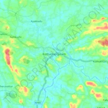
Nombre: Mapa topográfico Kothamangalam, altitud, relieve.
Lugar: Kothamangalam, Ernakulam district, Kerala, 686666, India (10.02403 76.58182 10.10403 76.66182)
Altitud media: 34 m
Altitud mínima: 15 m
Altitud máxima: 90 m
Kothamangalam is situated in the eastern part of the Ernakulam district. Kothamangalam is known as the Gateway of Highrange. According to the division of the geographical regions of Kerala, i.e. High-lands, Mid-lands and Low-lands, Kothamangalam is in a Mid-land region. The general topography is hilly. The Munnar hill station is around 85 kilometres from Kothamangalam.