
Mapa topográfico Brixton
Mapa interactivo
Haga clic en el mapa para ver la altitud.
Acerca de este mapa
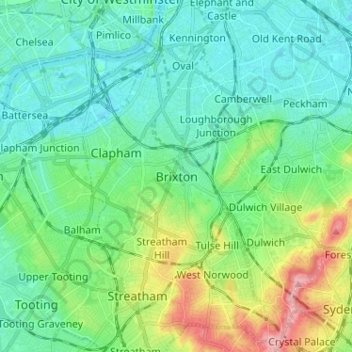
Nombre: Mapa topográfico Brixton, altitud, relieve.
Lugar: Brixton, Greater London, England, SW2 1SS, United Kingdom (51.41680 -0.15680 51.49680 -0.07680)
Altitud media: 29 m
Altitud mínima: -2 m
Altitud máxima: 114 m
Otros mapas topográficos
Haga clic en un mapa para ver su topografía, su altitud y su relieve.
South East England
Near Weybridge are the UK headquarters of Sony with SSP Group (situated in Byfleet) and Procter & Gamble (next door to each other on The Heights Business Park near the former Brooklands racing circuit) with Kia Motors UK and Petroleum Geo-Services UK, and Gallaher Group (cigarettes) is to the north, next to…
Altitud media: 69 m
Todmorden
United Kingdom > England > Calderdale
Todmorden Town Hall, which was designed in the Neo-Classical style, dominates the centre of the town. The building straddles the Walsden Water, a tributary of the River Calder, and was situated in both Lancashire and Yorkshire until the administrative county boundary was moved on 1 January 1888. Designed by…
Altitud media: 311 m
London
London's topography is characterized by a gently rolling terrain shaped by the River Thames and its tributaries. The city lies within the London Basin, a natural depression bordered by higher grounds such as the North Downs to the south and the Chiltern Hills to the northwest. The Thames flows west to east,…
Altitud media: 66 m
Birmingham
Birmingham is a snowy city relative to other large UK conurbations, due to its inland location and comparatively high elevation. Between 1961 and 1990 Birmingham Airport averaged 13.0 days of snow lying annually, compared to 5.33 at London Heathrow. Snow showers often pass through the city via the Cheshire gap…
Altitud media: 138 m
Kent
Kent was also the location of the largest number of art schools in the country during the nineteenth century, estimated by the art historian David Haste, to approach two hundred. This is believed to be the result of Kent being a front line county during the Napoleonic Wars. At this time, before the invention…
Altitud media: 37 m
Suffolk
The west of the county lies on more resistant Cretaceous chalk. This chalk is responsible for a sweeping tract of largely downland landscapes that stretches from Dorset in the south west to Dover in the south east and north through East Anglia to the Yorkshire Wolds. The chalk is less easily eroded so forms…
Altitud media: 35 m
Cornwall
The interior of the county consists of a roughly east–west spine of infertile and exposed upland, with a series of granite intrusions, such as Bodmin Moor, which contains the highest land within Cornwall. From east to west, and with approximately descending altitude, these are Bodmin Moor, Hensbarrow north…
Altitud media: 55 m
Bath
United Kingdom > England > Bath and North East Somerset
Bath is in the Avon Valley and is surrounded by limestone hills as it is near the southern edge of the Cotswolds, a designated Area of Outstanding Natural Beauty, and the limestone Mendip Hills rise around 7 miles (11 km) south of the city. The hills that surround and make up the city have a maximum altitude…
Altitud media: 100 m
East of England
The East of England region has the lowest elevation range in the UK. Twenty percent of the region is below mean sea level, most of this in North Cambridgeshire, Norfolk and on the Essex Coast. Most of the remaining area is of low elevation, with extensive glacial deposits. The Fens, a large area of reclaimed…
Altitud media: 39 m
Lake District National Park
The Lake District is a roughly circular upland massif, deeply dissected by a broadly radial pattern of major valleys which are largely the result of repeated glaciations over the last 2 million years. The apparent radial pattern is not from a central dome, but from an axial watershed extending from St Bees…
Altitud media: 206 m
Warwick
United Kingdom > England > Warwickshire
Warwick experiences the usual English maritime climate, marked by a narrow temperature range, mild winters and cool summers. The nearest official Met Office weather station is at Wellesbourne, about 6 miles (10 km) south of the town centre and at a similar elevation. The absolute maximum temperature (also the…
Altitud media: 87 m
Dartmoor National Park
United Kingdom > England > Devon
Rainfall tends to be associated with Atlantic depressions or with convection. In summer, convection caused by solar surface heating sometimes forms shower clouds and a large proportion of rainfall falls from showers and thunderstorms at this time of year. The wettest months are November and December and on the…
Altitud media: 239 m
Lincoln
United Kingdom > England > Lincolnshire
Lincoln lies 157 mi (253 km) north of London, at an altitude of 67 ft (20.4 m) by the River Witham up to 246 ft (75.0 m) on Castle Hill. It fills a gap in the Lincoln Cliff escarpment, which runs north and south through central Lincolnshire, with altitudes up to 200 feet (61 metres). The city lies on the River…
Altitud media: 29 m
Cambridge
United Kingdom > England > Cambridge
The city, like most of the UK, has a maritime climate highly influenced by the Gulf Stream. Located in the driest region of Britain, Cambridge's rainfall averages around 570 mm (22.44 in) per year, around half the national average, with some years occasionally falling into the semi-arid (under 500 mm (19.69…
Altitud media: 18 m
Chineham
United Kingdom > England > Hampshire > Basingstoke and Deane > Basingstoke
Altitud media: 78 m
Berkshire
United Kingdom > England > Reading
All of the county is drained by the Thames. Berkshire divides into two topological (and associated geological) sections: east and west of Reading. North-east Berkshire has the low calciferous (limestone) m-shaped bends of the Thames south of which is a broader, clayey, gravelly former watery plain or belt from…
Altitud media: 100 m
Exeter
United Kingdom > England > Devon
The city of Exeter was established on the eastern bank of the River Exe on a ridge of land backed by a steep hill. It is at this point that the Exe, having just been joined by the River Creedy, opens onto a wide flood plain and estuary which results in quite common flooding. Historically this was the lowest…
Altitud media: 56 m
St Albans
United Kingdom > England > Hertfordshire > St Albans
St Albans was an ancient borough created following the dissolution of the monastery in 1539. It consisted of the ancient parish of St Albans (also known as the Abbey parish) and parts of St Michael and St Peter. The municipal corporation was reformed by the Municipal Corporations Act 1835 and the boundary was…
Altitud media: 100 m
Sturton le Steeple
United Kingdom > England > Nottinghamshire > Bassetlaw > Sturton le Steeple
Altitud media: 20 m
Cheriton Fitzpaine
United Kingdom > England > Devon > Mid Devon > Cheriton Fitzpaine
Altitud media: 143 m
Worthington
United Kingdom > England > Leicestershire > North West Leicestershire
Altitud media: 103 m