
Haz una donación
Mapa topográfico East Riding of Yorkshire
Haga clic en el mapa para ver la altitud.
Haz una donación
East Riding of Yorkshire
The western part of the district in the Vale of York borders on and is drained by the River Derwent. The landscape is generally low-lying and flat although minor ridges and glacial moraines provide some variations in topography. Where there are dry sandy soils there are remnants of historic heathlands and ancient semi-natural woodlands. Arable fields dominate the land cover of the area and grasslands are infrequent. There are very few flood meadows left, although some significant areas remain on the lower reaches of the River Derwent.
Haz una donación
Acerca de este mapa
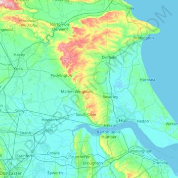
Nombre: Mapa topográfico East Riding of Yorkshire, altitud, relieve.
Altitud media: 30 m
Altitud mínima: -2 m
Altitud máxima: 302 m
Haz una donación
Otros mapas topográficos
Haga clic en un mapa para ver su topografía, su altitud y su relieve.
Leeds
Lying in the eastern foothills of the Pennines, there is a significant variation in elevation within the city's built-up area. The district ranges from 1,115 feet (340 m) in the far west on the slopes of Ilkley Moor to about 33 feet (10 m) where the rivers Aire and Wharfe cross the eastern boundary. Land rises…
Altitud media: 94 m
Haz una donación
Haz una donación
Haz una donación
Haz una donación
Tottenham
Tottenham's elevation is approximately 33 ft (10 m) above sea level.
Altitud media: 25 m
Cambridge
United Kingdom > England > Cambridge
The city, like most of the UK, has a maritime climate highly influenced by the Gulf Stream. Located in the driest region of Britain, Cambridge's rainfall averages around 570 mm (22.44 in) per year, around half the national average, with some years occasionally falling into the semi-arid (under 500 mm (19.69…
Altitud media: 18 m
Haz una donación
Portsmouth
United Kingdom > England > Hampshire > Portsmouth
By road, Portsmouth lies 73.5 miles (118.3 km) from Central London, 49.5 miles (79.7 km) west of Brighton, and 22.3 miles (35.9 km) east of Southampton. Portsmouth is situated primarily on Portsea Island and is the United Kingdom's only island city, although parts of it have expanded onto the mainland. Gosport…
Altitud media: 28 m
Swindon
United Kingdom > England > Swindon
Swindon has an oceanic climate (Cfb in the Köppen climate classification), like the vast majority of the British Isles, with cool winters and warm summers. The nearest official weather station is RAF Lyneham, about 10 miles (16 km) west southwest of Swindon town centre. The weather station's elevation is 145…
Altitud media: 108 m
Haz una donación
Haz una donación
Plymouth
United Kingdom > England > Devon > Plymouth
The River Plym, which flows off Dartmoor to the north-east, forms a smaller estuary to the east of the city called Cattewater. Plymouth Sound is protected from the sea by the Plymouth Breakwater, in use since 1814. In the Sound is Drake's Island which is seen from Plymouth Hoe, a flat public area on top of…
Altitud media: 81 m
Haz una donación
Haz una donación
Haz una donación
Hull
United Kingdom > England > Kingston upon Hull
Kingston upon Hull is on the northern bank of the Humber Estuary. The city centre is west of the River Hull and close to the Humber. The city is built upon alluvial and glacial deposits which overlie chalk rocks but the underlying chalk has no influence on the topography. The land within the city is generally…
Altitud media: 21 m
Haz una donación
Norton Lake
United Kingdom > England > Hampshire > Winchester > Sutton Scotney > Norton
Altitud media: 72 m
Haz una donación
Scafell Pike
United Kingdom > England > Cumberland
Scafell Pike (/ˈskɔːfɛl paɪk/) is the highest and the most prominent mountain in England, at an elevation of 978 metres (3,209 ft) above sea level. It is located in the Lake District National Park, in Cumbria, and is part of the Southern Fells and the Scafell massif.
Altitud media: 679 m
Haz una donación
Salisbury
United Kingdom > England > Salisbury
Bishop of Salisbury Hubert Walter was instrumental in the negotiations with Saladin during the Third Crusade, but he spent little time in his diocese prior to his elevation to archbishop of Canterbury. The brothers Herbert and Richard Poore succeeded him and began planning the relocation of the cathedral into…
Altitud media: 96 m
Peterborough
United Kingdom > England > Cambridgeshire
The local topography is flat, and in some places, the land lies below sea level, for example in parts of the Fens to the east and to the south of Peterborough. Human settlement in the area began before the Bronze Age, as can be seen at the Flag Fen archaeological site to the east of the current city centre,…
Altitud media: 17 m
Haz una donación
West Bromwich
United Kingdom > England > Sandwell
The town's football club is West Bromwich Albion. The club was founded in 1878 by workers from George Salter's Spring Works in West Bromwich. In 1888 it became one of the 12 founder members of the Football League along with their two fiercest local rivals, Aston Villa and Wolverhampton Wanderers. Albion have…
Altitud media: 149 m
Haz una donación
Low Pike
United Kingdom > England > Westmorland and Furness
Despite its modest height, Alfred Wainwright gave Low Pike a separate chapter in his Pictorial Guide to the Lakeland Fells because "it is sufficiently elevated above the deep valleys of Scandale and Rydale to give an impression of loftiness which exaggerates its modest altitude." Bill Birkett also mentions the…
Altitud media: 364 m
Basingstoke
United Kingdom > England > Hampshire > Basingstoke and Deane
Situated in a valley through the Hampshire Downs at an average elevation of 88 metres (289 ft) Basingstoke is a major interchange between Reading, Newbury, Andover, Winchester, and Alton, and lies on the natural trade route between the southwest of England and London. The area had been something of an…
Altitud media: 110 m
Haz una donación
Croydon
United Kingdom > England > Greater London
Several apartment developments, for instance Altitude 25 (completed 2010), have been built in recent years, and several more are being built or planned. The construction of Saffron Square, which includes a 43-storey tower, began on Wellesley Road in 2011 and was completed in 2016. Other developments with…
Altitud media: 70 m
Reading
United Kingdom > England > Reading
Mary Russell Mitford lived in Reading for a number of years and then spent the rest of her life just outside the town at Three Mile Cross and Swallowfield. The fictional Belford Regis of her eponymous novel, first published in 1835, is largely based on Reading. Described with topographical accuracy, it is…
Altitud media: 56 m
Haz una donación
Haz una donación
Haz una donación
Royton
Described in Samuel Lewis's A Topographical Dictionary of England (1848) as being in "aspect rather wild", Royton lies in a shallow valley amongst undulating land. The sources of the rivers Irk and Beal are to the northeast and east respectively. The Irk meanders southwesterly into Chadderton, and then onwards…
Altitud media: 181 m
Yorkshire Water Flood Alleviation Scheme
United Kingdom > England > North Yorkshire > Filey > Gristhorpe
Altitud media: 36 m
Haz una donación
Haz una donación
City of London
United Kingdom > England > City of London > City of London
The elevation of the City ranges from sea level at the Thames to 21.6 metres (71 ft) at the junction of High Holborn and Chancery Lane. Two small but notable hills are within the historic core, Ludgate Hill to the west and Cornhill to the east. Between them ran the Walbrook, one of the many "lost" rivers or…
Altitud media: 42 m
Haz una donación
Bedford
United Kingdom > England > Bedford
As with the rest of the United Kingdom, Bedford has a maritime climate, with a limited range of temperatures, and generally even rainfall throughout the year. The nearest Met Office weather station to Bedford is Bedford (Thurleigh) airport, about 6.5 miles (10.5 km) north of Bedford town centre at an elevation…
Altitud media: 37 m
Haz una donación
Haz una donación
Haz una donación