
Mapa topográfico Inishowen
Mapa interactivo
Haga clic en el mapa para ver la altitud.
Acerca de este mapa
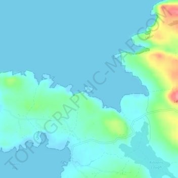
Nombre: Mapa topográfico Inishowen, altitud, relieve.
Altitud media: 13 m
Altitud mínima: -2 m
Altitud máxima: 90 m
Otros mapas topográficos
Haga clic en un mapa para ver su topografía, su altitud y su relieve.
Ballybrack
Ballybrack, Moville ED, Inishowen Municipal District, County Donegal, Ireland
Altitud media: 147 m
Kiltole
Kiltole, Figart ED, Lifford-Stranorlar Municipal District, County Donegal, Ireland
Altitud media: 49 m
Teelin
Teelin, Donegal Municipal District, County Donegal, Ireland
Altitud media: 88 m
Carn Hill
Ireland > County Donegal > Letterkenny
Carn Hill, Letterkenny, County Donegal, F92 W8CY, Ireland
Altitud media: 144 m
Lisnenan
Ireland > County Donegal > Letterkenny
Lisnenan, Letterkenny Rural ED, Letterkenny, County Donegal, F92 W8CY, Ireland
Altitud media: 101 m
Glencar Scotch
Ireland > County Donegal > Letterkenny
Glencar Scotch, Letterkenny Rural ED, Letterkenny, County Donegal, Ireland
Altitud media: 134 m
Trillick
Trillick, Buncrana Rural ED, Inishowen Municipal District, County Donegal, Ulster, Ireland
Altitud media: 106 m
Glen Lough
Ireland > County Donegal > Letterkenny
Glen Lough, Millford ED, Letterkenny, County Donegal, Ulster, Ireland
Altitud media: 89 m
Stragraddy
Ireland > County Donegal > Letterkenny
Stragraddy, Termon ED, Letterkenny, County Donegal, Ulster, Ireland
Altitud media: 118 m
Letterkenny
Ireland > County Donegal > Letterkenny
Letterkenny, Letterkenny Municipal District, County Donegal, F92 PD92, Ireland
Altitud media: 93 m
Church Hill
Ireland > County Donegal > Letterkenny
Church Hill, Church Hill ED, Letterkenny, County Donegal, Ireland
Altitud media: 117 m
Gortahork
Gortahork, Gleneely ED, Lifford-Stranorlar Municipal District, County Donegal, Ireland
Altitud media: 173 m
Bomany
Ireland > County Donegal > Letterkenny
Bomany, Ballymacool ED, Letterkenny, County Donegal, Ulster, Ireland
Altitud media: 62 m
Murvagh Upper Glebe
Murvagh Upper Glebe, Ballintra ED, Donegal Municipal District, County Donegal, Ireland
Altitud media: 7 m
Inver Glebe
Inver Glebe, Inver ED, Donegal Municipal District, County Donegal, Ireland
Altitud media: 26 m
Castlefinn
Castlefinn, Castlefinn ED, Lifford-Stranorlar Municipal District, County Donegal, Ulster, Ireland
Altitud media: 27 m
Inishowen Municipal District
Inishowen Municipal District, County Donegal, Ireland
Altitud media: 59 m
Moness
Moness, Burt ED, Inishowen Municipal District, County Donegal, Ireland
Altitud media: 53 m
Moness
Moness, St Johnstown Electoral Division, Lifford-Stranorlar Municipal District, County Donegal, Ireland
Altitud media: 55 m
Toulett
Toulett, Burt ED, Inishowen Municipal District, County Donegal, Ireland
Altitud media: 89 m
Sallaghagrane
Ireland > County Donegal > Letterkenny
Sallaghagrane, Letterkenny Rural ED, Letterkenny, County Donegal, Ulster, Ireland
Altitud media: 57 m
Dungloe River
Dungloe River, Dunglow ED, Glenties Municipal District, County Donegal, Ulster, F94 W974, Ireland
Altitud media: 24 m
Murvagh Beach
Murvagh Beach, Ballintra ED, Donegal Municipal District, County Donegal, Ireland
Altitud media: 2 m
Cashel
Cashel, Donegal Municipal District, County Donegal, Ireland
Altitud media: 108 m
Lifford-Stranorlar Municipal District
Lifford-Stranorlar Municipal District, County Donegal, Ulster, Ireland
Altitud media: 142 m
Cark
Cark, Lettermore ED, Lifford-Stranorlar Municipal District, County Donegal, Ireland
Altitud media: 256 m
Tory Island
Tory Island, Meenaclady, Glenties Municipal District, County Donegal, Ireland
Altitud media: 3 m
Horn Head
Horn Head, Dunfanaghy Electoral Division, Glenties Municipal District, County Donegal, F92 H0CY, Ireland
Altitud media: 31 m
Creeslough ED
Creeslough ED, Glenties Municipal District, County Donegal, Ulster, F92 W803, Ireland
Altitud media: 43 m
Kilmacrennan
Ireland > County Donegal > Kilmacrennan
Kilmacrennan, Letterkenny Municipal District, County Donegal, Ireland
Altitud media: 63 m
Drumaneary
Drumaneary, Tantallon ED, Donegal Municipal District, County Donegal, Ireland
Altitud media: 23 m
Gortnamuck
Gortnamuck, Cloghard ED, Lifford-Stranorlar Municipal District, County Donegal, Ireland
Altitud media: 87 m
Melmore Head
Ireland > County Donegal > Letterkenny
Melmore Head, Atlantic Way, Rosguill ED, Letterkenny, County Donegal, Ireland
Altitud media: 9 m
Drumnacross
Drumnacross, Ardara ED, Glenties Municipal District, County Donegal, Ireland
Altitud media: 88 m
Donegal Municipal District
Donegal Municipal District, County Donegal, Ulster, Ireland
Altitud media: 120 m
Dunduffsfort
Dunduffsfort, Newtown Cunningham ED, Inishowen Municipal District, County Donegal, Ireland
Altitud media: 76 m
Kildoney Glebe
Kildoney Glebe, Ballyshannon Rural ED, Donegal Municipal District, County Donegal, Ireland
Altitud media: 13 m
Ballyargus
Ballyargus, Redcastle ED, Inishowen Municipal District, County Donegal, Ireland
Altitud media: 169 m
Dunglow
Dunglow, Dunglow ED, Glenties Municipal District, County Donegal, Ulster, Ireland
Altitud media: 26 m
Duncap Isle
Duncap Isle, Dunfanaghy Electoral Division, Glenties Municipal District, County Donegal, F92 H0CY, Ireland
Altitud media: 38 m
Lough Derryduff
Lough Derryduff, Maas ED, Glenties Municipal District, County Donegal, Ireland
Altitud media: 41 m
Inishinny
Inishinny, Rutland ED, Glenties Municipal District, County Donegal, Ireland
Altitud media: 2 m
Largynagreana
Largynagreana, Killybegs ED, Donegal Municipal District, County Donegal, Ireland
Altitud media: 93 m
Speenoge
Speenoge, Burt ED, Inishowen Municipal District, County Donegal, Ireland
Altitud media: 79 m
Cullion
Cullion, Lettermacaward ED, Glenties Municipal District, County Donegal, Ireland
Altitud media: 29 m