
Haz una donación
Mapa topográfico Central Bedfordshire
Haga clic en el mapa para ver la altitud.
Haz una donación
Acerca de este mapa
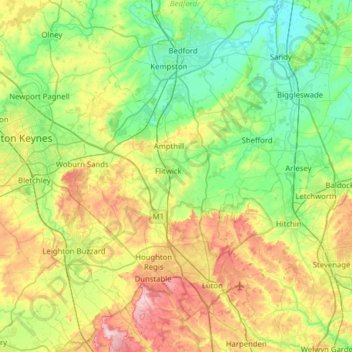
Nombre: Mapa topográfico Central Bedfordshire, altitud, relieve.
Lugar: Central Bedfordshire, England, United Kingdom (51.80509 -0.70218 52.19091 -0.14396)
Altitud media: 89 m
Altitud mínima: 16 m
Altitud máxima: 250 m
Haz una donación
Otros mapas topográficos
Haga clic en un mapa para ver su topografía, su altitud y su relieve.
Swindon
United Kingdom > England > Swindon
Swindon has an oceanic climate (Cfb in the Köppen climate classification), like the vast majority of the British Isles, with cool winters and warm summers. The nearest official weather station is RAF Lyneham, about 10 miles (16 km) west southwest of Swindon town centre. The weather station's elevation is 145…
Altitud media: 108 m
Haz una donación
Haz una donación
Reading
United Kingdom > England > Reading
Mary Russell Mitford lived in Reading for a number of years and then spent the rest of her life just outside the town at Three Mile Cross and Swallowfield. The fictional Belford Regis of her eponymous novel, first published in 1835, is largely based on Reading. Described with topographical accuracy, it is…
Altitud media: 56 m
Haz una donación
Cambridge
United Kingdom > England > Cambridge
The city, like most of the UK, has a maritime climate highly influenced by the Gulf Stream. Located in the driest region of Britain, Cambridge's rainfall averages around 570 mm (22.44 in) per year, around half the national average, with some years occasionally falling into the semi-arid (under 500 mm (19.69…
Altitud media: 18 m
City of London
United Kingdom > England > City of London > City of London
The elevation of the City ranges from sea level at the Thames to 21.6 metres (71 ft) at the junction of High Holborn and Chancery Lane. Two small but notable hills are within the historic core, Ludgate Hill to the west and Cornhill to the east. Between them ran the Walbrook, one of the many "lost" rivers or…
Altitud media: 42 m
Haz una donación
Richmond
United Kingdom > England > London
The town centre lies just below 33 ft (10m) above sea level. South of the town centre, rising from Richmond Bridge to an elevation of 165 ft (50m), is Richmond Hill. Just beyond the summit of Richmond Hill is Richmond Park, an area of 2,360 acres (9.55 km2; 3.7 sq mi) of wild heath and woodland originally…
Altitud media: 17 m
Haz una donación
Blencathra
United Kingdom > England > Westmorland and Furness > Threlkeld
The Northern Fells make up a roughly circular upland area about 10 miles (16 km) wide. At the centre is the marshy depression of Skiddaw Forest — a treeless plateau at an altitude of 1,300 ft (400 m) — and flowing outward from here are the rivers which divide the area into three sectors. Between the…
Altitud media: 577 m
Haz una donación
Leeds
Lying in the eastern foothills of the Pennines, there is a significant variation in elevation within the city's built-up area. The district ranges from 1,115 feet (340 m) in the far west on the slopes of Ilkley Moor to about 33 feet (10 m) where the rivers Aire and Wharfe cross the eastern boundary. Land rises…
Altitud media: 94 m
Cley Hill
United Kingdom > England > Wiltshire
Cley Hill (grid reference ST838449) is a prominent hill to the west of Warminster in Wiltshire, England. Its summit has a commanding view of the Wiltshire / Somerset county boundary, at 244 metres (801 ft) elevation. The land is in Corsley parish and is owned by the National Trust.
Altitud media: 157 m
Little Solsbury Hill
United Kingdom > England > Bath and North East Somerset > Batheaston
Altitud media: 88 m
Haz una donación
St Albans
United Kingdom > England > Hertfordshire > St Albans
St Albans was an ancient borough created following the dissolution of the monastery in 1539. It consisted of the ancient parish of St Albans (also known as the Abbey parish) and parts of St Michael and St Peter. The municipal corporation was reformed by the Municipal Corporations Act 1835 and the boundary was…
Altitud media: 100 m
Hull
United Kingdom > England > Kingston upon Hull
Kingston upon Hull is on the northern bank of the Humber Estuary. The city centre is west of the River Hull and close to the Humber. The city is built upon alluvial and glacial deposits which overlie chalk rocks but the underlying chalk has no influence on the topography. The land within the city is generally…
Altitud media: 21 m
Haz una donación
Haz una donación
Haz una donación
Haz una donación
Haz una donación
Haz una donación
Peterborough
United Kingdom > England > Cambridgeshire
The local topography is flat, and in some places, the land lies below sea level, for example in parts of the Fens to the east and to the south of Peterborough. Human settlement in the area began before the Bronze Age, as can be seen at the Flag Fen archaeological site to the east of the current city centre,…
Altitud media: 17 m
Haz una donación
Haz una donación
Shellbrook
United Kingdom > England > Leicestershire > North West Leicestershire > Ashby-de-la-Zouch > Blackfordby
Altitud media: 128 m
Haz una donación
Portsmouth
United Kingdom > England > Hampshire > Portsmouth
By road, Portsmouth lies 73.5 miles (118.3 km) from Central London, 49.5 miles (79.7 km) west of Brighton, and 22.3 miles (35.9 km) east of Southampton. Portsmouth is situated primarily on Portsea Island and is the United Kingdom's only island city, although parts of it have expanded onto the mainland. Gosport…
Altitud media: 28 m
Salisbury
United Kingdom > England > Salisbury
Bishop of Salisbury Hubert Walter was instrumental in the negotiations with Saladin during the Third Crusade, but he spent little time in his diocese prior to his elevation to archbishop of Canterbury. The brothers Herbert and Richard Poore succeeded him and began planning the relocation of the cathedral into…
Altitud media: 96 m
Haz una donación
Hunts Green
United Kingdom > England > Warwickshire > North Warwickshire > Middleton CP
Altitud media: 81 m
Haz una donación
Haz una donación
Ely
United Kingdom > England > Ely
For over 800 years the cathedral and its associated buildings—built on an elevation 68 feet (21 m) above the nearby fens—have visually influenced the city and its surrounding area. Geographer John Jones, writing in 1924, reports that "from the roof of King's Chapel in Cambridge, on a clear day, Ely can be…
Altitud media: 13 m
Tewin Wood
United Kingdom > England > Hertfordshire > East Hertfordshire > Burnham Green
Altitud media: 101 m
Haz una donación
Windsor Castle
United Kingdom > England > Royal Borough of Windsor and Maidenhead > Windsor > Clewer Village
Altitud media: 23 m
Haz una donación
Haz una donación
Haz una donación
Croydon
United Kingdom > England > Greater London
Several apartment developments, for instance Altitude 25 (completed 2010), have been built in recent years, and several more are being built or planned. The construction of Saffron Square, which includes a 43-storey tower, began on Wellesley Road in 2011 and was completed in 2016. Other developments with…
Altitud media: 70 m
Plymouth
United Kingdom > England > Devon > Plymouth
The River Plym, which flows off Dartmoor to the north-east, forms a smaller estuary to the east of the city called Cattewater. Plymouth Sound is protected from the sea by the Plymouth Breakwater, in use since 1814. In the Sound is Drake's Island which is seen from Plymouth Hoe, a flat public area on top of…
Altitud media: 81 m
Haz una donación
Wistman's Wood (Nature Reserve)
United Kingdom > England > Devon > West Devon
Wistman's Wood is one of Britain's last remaining ancient temperate rainforests and one of three remote high-altitude oakwoods on Dartmoor in Devon, England. The first written document to mention Wistman's Wood dates to the 17th century, while more recent tree-ring studies show that individual trees could be…
Altitud media: 433 m
Haz una donación