
Mapa topográfico Gran Bretaña
Mapa interactivo
Haga clic en el mapa para ver la altitud.
Acerca de este mapa
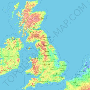
Nombre: Mapa topográfico Gran Bretaña, altitud, relieve.
Lugar: Gran Bretaña, Reino Unido (49.95870 -6.22788 58.67208 1.76322)
Altitud media: 52 m
Altitud mínima: -6 m
Altitud máxima: 1,233 m
Otros mapas topográficos
Haga clic en un mapa para ver su topografía, su altitud y su relieve.
Dryburgh Abbey
Reino Unido > Escocia > Scottish Borders > Dryburgh > Dryburgh Mains
Altitud media: 100 m
Perth
Reino Unido > Escocia > Perth and Kinross
Hallazgos recientes demuestran que la zona de Perth fue habitada por tribus de cazadores-recolectores del Mesolítico hace unos 8000 años. Al este de la ciudad, cerca del río Tay, se han encontrado restos de formaciones megalíticas del año 4000 a. C., y una embarcación sorprendentemente bien conservada…
Altitud media: 131 m
Fort Augustus
Reino Unido > Escocia > Highland
Cuando con el resto de las Islas Británicas y Escocia, Fort Augustus experimenta un clima marítimo con veranos frescos e inviernos suaves. Cuando con mucho del área circundante, niveles de sol son abajo, alrededor 1000 horas por annum, y las temperaturas imprevisibles - Fort Augustus aguanta la junta del…
Altitud media: 115 m
Rhynie
Reino Unido > Escocia > Aberdeenshire
Rhynie es una localidad escocesa perteneciente al condado de Aberdeenshire a unos 22 kilómetros al noroeste de Alford. Esta antigua ciudad, conocida durante la edad media como Muir of Rhynie, posee varios monumentos megalíticos pertenecientes a los pueblos pictos que poblaron el norte de la isla de Gran…
Altitud media: 234 m