
Mapa topográfico Marion
Mapa interactivo
Haga clic en el mapa para ver la altitud.
Acerca de este mapa
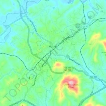
Nombre: Mapa topográfico Marion, altitud, relieve.
Altitud media: 435 m
Altitud mínima: 365 m
Altitud máxima: 690 m
With an elevation of 1,400 feet, Marion's climate is fairly warm during summer (which are typically longer than lower elevation areas in the United States that get the same average high and low temperatures in the summer), when temperatures tend to be in the 80s and 90s, and moderately cold during the winter, with temperatures typically in the 30s and 40s.
Otros mapas topográficos
Haga clic en un mapa para ver su topografía, su altitud y su relieve.
West Marion
United States > North Carolina > McDowell County
West Marion, McDowell County, North Carolina, 28752, United States
Altitud media: 449 m
Nebo
United States > North Carolina > McDowell County
Nebo, McDowell County, North Carolina, 28761, United States
Altitud media: 394 m
Little Switzerland
United States > North Carolina > McDowell County
Little Switzerland, McDowell County, North Carolina, 28749, United States
Altitud media: 935 m
Old Fort
United States > North Carolina > McDowell County > Old Fort
Old Fort, McDowell County, North Carolina, United States
Altitud media: 474 m