
Mapa topográfico Madison
Mapa interactivo
Haga clic en el mapa para ver la altitud.
Acerca de este mapa
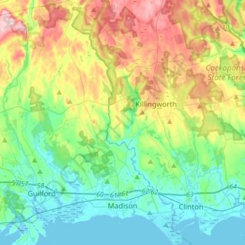
Nombre: Mapa topográfico Madison, altitud, relieve.
Altitud media: 69 m
Altitud mínima: -2 m
Altitud máxima: 219 m
Otros mapas topográficos
Haga clic en un mapa para ver su topografía, su altitud y su relieve.
Lake Whitney
United States > Connecticut > South Central COG > Hamden
Lake Whitney, Hamden, South Central COG, Connecticut, United States
Altitud media: 25 m
Branford Hills
United States > Connecticut > South Central COG > Branford
Branford Hills, Branford, South Central COG, Connecticut, 06405, United States
Altitud media: 12 m
North Guilford
United States > Connecticut > South Central COG > Guilford
North Guilford, Guilford, South Central COG, Connecticut, United States
Altitud media: 79 m
Whitney Peak
United States > Connecticut > South Central COG > Hamden
Whitney Peak, Hamden, South Central COG, Connecticut, 06517, United States
Altitud media: 19 m