
Mapa topográfico Cumberland
Mapa interactivo
Haga clic en el mapa para ver la altitud.
Acerca de este mapa
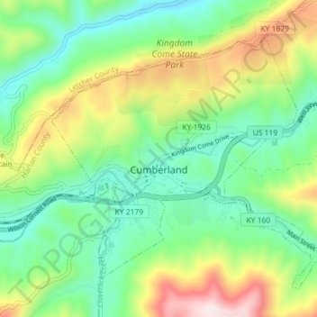
Nombre: Mapa topográfico Cumberland, altitud, relieve.
Lugar: Cumberland, Harlan County, Kentucky, 40823, United States (36.95876 -83.02875 37.00153 -82.95724)
Altitud media: 591 m
Altitud mínima: 362 m
Altitud máxima: 1,052 m
Cumberland is located in northeastern Harlan County at 36°58′37″N 82°59′15″W / 36.97694°N 82.98750°W / 36.97694; -82.98750 (36.977016, -82.987434) in the valley of the Poor Fork of the Cumberland River, where it is joined by Looney Creek from the southeast and Cloverlick Creek from the south. The city limits extend to the north up to the crest of Pine Mountain, which forms the Letcher County line. Elevations within the city range from 1,400 feet (430 m) above sea level along the Poor Fork on the west side of town to 2,700 feet (820 m) atop Pine Mountain.
Otros mapas topográficos
Haga clic en un mapa para ver su topografía, su altitud y su relieve.
Lenarue
United States > Kentucky > Harlan County
Lenarue, Harlan County, Kentucky, 40818, United States
Altitud media: 519 m
Pathfork
United States > Kentucky > Harlan County
Pathfork, Harlan County, Kentucky, 40863, United States
Altitud media: 534 m
Bardo
United States > Kentucky > Harlan County
Bardo, Harlan County, Kentucky, 40830, United States
Altitud media: 634 m
Holmes Mill
United States > Kentucky > Harlan County
Holmes Mill, Harlan County, Kentucky, 40843, United States
Altitud media: 758 m
Pansy
United States > Kentucky > Harlan County
Pansy, Harlan County, Kentucky, 40830, United States
Altitud media: 602 m
Putney
United States > Kentucky > Harlan County
Putney, Harlan County, Kentucky, 40865, United States
Altitud media: 601 m
Alva
United States > Kentucky > Harlan County
Alva, Harlan County, Kentucky, 40863, United States
Altitud media: 652 m
Fresh Meadows
United States > Kentucky > Harlan County
Fresh Meadows, Harlan County, Kentucky, 40824, United States
Altitud media: 462 m
Pine Mountain
United States > Kentucky > Harlan County
Pine Mountain, Harlan County, Kentucky, United States
Altitud media: 536 m
Kenvir
United States > Kentucky > Harlan County
Kenvir, Harlan County, Kentucky, 40847, United States
Altitud media: 642 m
Ages
United States > Kentucky > Harlan County
Ages, Harlan County, Kentucky, 40801, United States
Altitud media: 587 m
Wallins Creek
United States > Kentucky > Harlan County
Wallins Creek, Harlan County, Kentucky, United States
Altitud media: 416 m
Lejunior
United States > Kentucky > Harlan County
Lejunior, Harlan County, Kentucky, 40865, United States
Altitud media: 585 m
Three Point
United States > Kentucky > Harlan County
Three Point, Harlan County, Kentucky, 40815, United States
Altitud media: 475 m
Louellen
United States > Kentucky > Harlan County
Louellen, Harlan County, Kentucky, 40849, United States
Altitud media: 698 m
Yancey
United States > Kentucky > Harlan County
Yancey, Harlan County, Kentucky, 40830, United States
Altitud media: 651 m
Big Laurel
United States > Kentucky > Harlan County
Big Laurel, Harlan County, Kentucky, 40808, United States
Altitud media: 574 m
Cawood
United States > Kentucky > Harlan County
Cawood, Harlan County, Kentucky, 40818, United States
Altitud media: 498 m
South Wallins
United States > Kentucky > Harlan County > South Wallins
South Wallins, Harlan County, Kentucky, 40873, United States
Altitud media: 528 m
Dayhoit
United States > Kentucky > Harlan County
Dayhoit, Harlan County, Kentucky, 40824, United States
Altitud media: 462 m
Molus
United States > Kentucky > Harlan County
Molus, Harlan County, Kentucky, 40819, United States
Altitud media: 467 m
Closplint
United States > Kentucky > Harlan County
Closplint, Harlan County, Kentucky, 40927, United States
Altitud media: 716 m
Loyall
United States > Kentucky > Harlan County
Loyall, Harlan County, Kentucky, 40854, United States
Altitud media: 434 m
Benham
United States > Kentucky > Harlan County
Benham, Harlan County, Kentucky, 40807, United States
Altitud media: 667 m
Totz
United States > Kentucky > Harlan County
Totz, Harlan County, Kentucky, 40870, United States
Altitud media: 638 m
Bledsoe
United States > Kentucky > Harlan County
Bledsoe, Harlan County, Kentucky, 40810, United States
Altitud media: 604 m
Creech
United States > Kentucky > Harlan County
Creech, Harlan County, Kentucky, United States
Altitud media: 661 m
River Ridge
United States > Kentucky > Harlan County
River Ridge, Harlan County, Kentucky, 40828, United States
Altitud media: 584 m
Evarts
United States > Kentucky > Harlan County
Evarts, Harlan County, Kentucky, United States
Altitud media: 533 m
Baxter
United States > Kentucky > Harlan County
Baxter, Harlan County, Kentucky, 40806, United States
Altitud media: 468 m
Coldiron
United States > Kentucky > Harlan County
Coldiron, Harlan County, Kentucky, 40819, United States
Altitud media: 472 m
Lynch
United States > Kentucky > Harlan County
Lynch, Harlan County, Kentucky, United States
Altitud media: 770 m
Divide
United States > Kentucky > Harlan County
Divide, Harlan County, Kentucky, 40865, United States
Altitud media: 657 m
Cranks
United States > Kentucky > Harlan County
Cranks, Harlan County, Kentucky, 40820, United States
Altitud media: 594 m
Harlan
United States > Kentucky > Harlan County
Harlan, Harlan County, Kentucky, 40831, United States
Altitud media: 493 m
Harlan
United States > Kentucky > Harlan County > Harlan > Harlan
Harlan, Harlan County, Kentucky, 40831, United States
Altitud media: 512 m