
Mapa topográfico Pierre
Mapa interactivo
Haga clic en el mapa para ver la altitud.
Acerca de este mapa
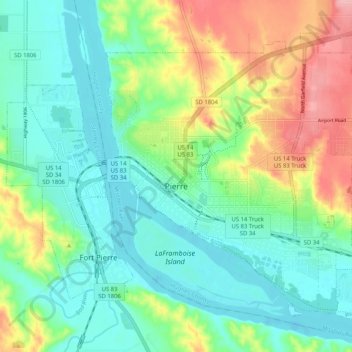
Nombre: Mapa topográfico Pierre, altitud, relieve.
Lugar: Pierre, Hughes County, South Dakota, 57501, United States (44.34066 -100.37174 44.40032 -100.26921)
Altitud media: 469 m
Altitud mínima: 429 m
Altitud máxima: 556 m
Otros mapas topográficos
Haga clic en un mapa para ver su topografía, su altitud y su relieve.
North Bend Lakeside Use Area
United States > South Dakota > Hughes County
North Bend Lakeside Use Area, Big Bend District, Hughes County, South Dakota, United States
Altitud media: 466 m
Blunt
United States > South Dakota > Hughes County
Blunt, Hughes County, South Dakota, United States
Altitud media: 504 m