
Mapa topográfico Isla Cozumel
Mapa interactivo
Haga clic en el mapa para ver la altitud.
Acerca de este mapa
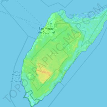
Nombre: Mapa topográfico Isla Cozumel, altitud, relieve.
Lugar: Isla Cozumel, Cozumel, Quintana Roo, Mexico (20.27200 -87.02520 20.59200 -86.72328)
Altitud media: 2 m
Altitud mínima: -3 m
Altitud máxima: 18 m
Cozumel has 5 main piers. Punta Langosta, the International Pier (SSA), and Puerta Maya are all piers for cruise ships. A ferry pier in San Miguel is used for passenger ferries to and from Playa del Carmen, as well as for cruise ship tenders. A fifth pier south of downtown is used only for vehicle ferries. Large parts of the island are covered with mangrove forest which has many endemic animal species. Cozumel is a flat island based on limestone, resulting in a karst topography. The highest natural point on the island is less than 15 m (49 ft) above sea level. The cenotes are water-filled sinkholes formed by water percolating through the soft limestone soil for thousands of years. Eighteen deep cenotes and more than 250 shallow bodies exist on the island. Many are under dense vegetation. Jade Cavern Cozumel (Cenote Chempita) near El Cedral is often visited by tourists.
Otros mapas topográficos
Haga clic en un mapa para ver su topografía, su altitud y su relieve.
San Miguel de Cozumel
Mexico > Quintana Roo > Cozumel
San Miguel de Cozumel, Cozumel, Quintana Roo, Mexico
Altitud media: 3 m