
Gracias por apoyar a este sitio ❤️
Haz una donación
Haz una donación
Mapa topográfico Bocholt
Haga clic en el mapa para ver la altitud.
Gracias por apoyar a este sitio ❤️
Haz una donación
Haz una donación
Bocholt
The climate in the region of Bocholt and West Münsterland is temperate with distinct maritime influences, with very mild winters in comparison to other German regions because of the proximity to the ocean and the low elevation. Summers are moderately warm. The average temperature in January is 2.7 °C (37 °F) and in July 18.4 °C (65 °F).
Gracias por apoyar a este sitio ❤️
Haz una donación
Haz una donación
Acerca de este mapa
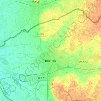
Nombre: Mapa topográfico Bocholt, altitud, relieve.
Lugar: Bocholt, Kreis Borken, North Rhine-Westphalia, Germany (51.78982 6.47251 51.91759 6.72119)
Altitud media: 31 m
Altitud mínima: 16 m
Altitud máxima: 60 m
Gracias por apoyar a este sitio ❤️
Haz una donación
Haz una donación
Otros mapas topográficos
Haga clic en un mapa para ver su topografía, su altitud y su relieve.
Gracias por apoyar a este sitio ❤️
Haz una donación
Haz una donación
Gracias por apoyar a este sitio ❤️
Haz una donación
Haz una donación