
Mapa topográfico Cluj-Napoca
Mapa interactivo
Haga clic en el mapa para ver la altitud.
Acerca de este mapa
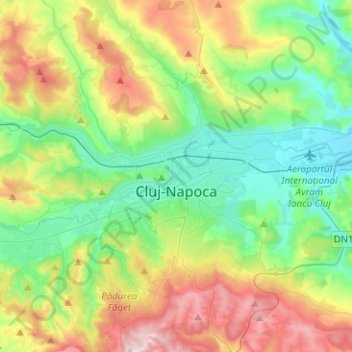
Nombre: Mapa topográfico Cluj-Napoca, altitud, relieve.
Lugar: Cluj-Napoca, Cluj Metropolitan Area, Cluj, Romania (46.68997 23.49924 46.86183 23.71833)
Altitud media: 480 m
Altitud mínima: 307 m
Altitud máxima: 829 m
A wide variety of flora grow in the Cluj-Napoca Botanical Garden; some animals have also found refuge there. The city has a number of other parks, of which the largest is the Central Park. This park was founded during the 19th century and includes an artificial lake with an island, as well as the largest casino in the city, Chios. Other notable parks in the city are the Iuliu Hațieganu Park of the Babeș-Bolyai University, which features some sport facilities, the Hașdeu Park, within the eponymous student housing district, the high-elevation Cetățuia, and the Opera Park, behind the building of the Cluj-Napoca Romanian Opera.
Otros mapas topográficos
Haga clic en un mapa para ver su topografía, su altitud y su relieve.
Peana
Romania > Cluj > Cluj-Napoca
Peana, Cluj-Napoca, Cluj Metropolitan Area, Cluj, 407271, Romania
Altitud media: 741 m
Mărtinești
Mărtinești, Tureni, Cluj Metropolitan Area, Cluj, 407563, Romania
Altitud media: 585 m
Muntele Băișorii
Muntele Băișorii, Băișoara, Cluj, 407068, Romania
Altitud media: 1,115 m