Geolocalizar

Mapa topográfico Nebeur

Mapa interactivo

Haga clic en el mapa para ver la altitud.

Acerca de este mapa

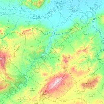
Nombre: Mapa topográfico Nebeur, altitud, relieve.

Lugar: Nebeur, Le Kef, Tunisie (36.20684 8.51670 36.45343 8.98734)

Altitud media: 388 m

Altitud mínima: 134 m

Altitud máxima: 1,071 m

Otros mapas topográficos

Haga clic en un mapa para ver su topografía, su altitud y su relieve.

Tajerouine

Tunisie > Le Kef

Tajerouine, Le Kef, Tunisie

Altitud media: 568 m

Kalaat Senan

Tunisie > Le Kef

Kalaat Senan, Le Kef, Tunisie

Altitud media: 661 m

Dahmani

Tunisie > Le Kef

Dahmani, Le Kef, 7170, Tunisie

Altitud media: 706 m

El Ksour

Tunisie > Le Kef

El Ksour, Le Kef, Tunisie

Altitud media: 822 m

Sakiet Sidi Youssef

Tunisie > Le Kef

Sakiet Sidi Youssef, Le Kef, Tunisie

Altitud media: 571 m

Menzel Salem

Tunisie > Le Kef

Menzel Salem, Tajerouine, Le Kef, Tunisie

Altitud media: 614 m

Sers

Tunisie > Le Kef

Sers, Le Kef, Tunisie

Altitud media: 601 m

Djerissa Centre

Tunisie > Le Kef

Djerissa Centre, DJerissa, Le Kef, Tunisie

Altitud media: 657 m