
Mapa topográfico Bloomington Heights
Mapa interactivo
Haga clic en el mapa para ver la altitud.
Acerca de este mapa
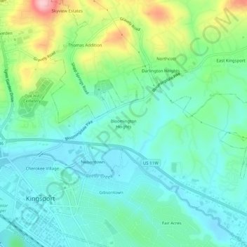
Nombre: Mapa topográfico Bloomington Heights, altitud, relieve.
Altitud media: 409 m
Altitud mínima: 359 m
Altitud máxima: 549 m
Otros mapas topográficos
Haga clic en un mapa para ver su topografía, su altitud y su relieve.
Fair Acres
United States > Tennessee > Sullivan County > Kingsport
Fair Acres, Kingsport, Sullivan County, East Tennessee, Tennessee, 37664, United States
Altitud media: 388 m
Gibsontown
United States > Tennessee > Sullivan County > Kingsport
Gibsontown, Kingsport, Sullivan County, East Tennessee, Tennessee, 37660, United States
Altitud media: 388 m
Preston Woods
United States > Tennessee > Sullivan County > Kingsport
Preston Woods, Kingsport, Sullivan County, Tennessee, 37664, United States
Altitud media: 432 m
Brairwood Acres
United States > Tennessee > Sullivan County > Kingsport
Brairwood Acres, Kingsport, Sullivan County, Tennessee, 37664, United States
Altitud media: 450 m
Kingsport
United States > Tennessee > Sullivan County > Kingsport
Kingsport, Sullivan County, Tennessee, 37660-3610, United States
Altitud media: 474 m
Lynn Garden
United States > Tennessee > Sullivan County > Kingsport
Lynn Garden, Kingsport, Sullivan County, Tennessee, 37665, United States
Altitud media: 436 m
Beechwood Village
United States > Tennessee > Sullivan County > Kingsport
Beechwood Village, Kingsport, Sullivan County, Tennessee, 37664, United States
Altitud media: 400 m