
Gracias por apoyar a este sitio ❤️
Haz una donación
Haz una donación
Mapa topográfico Dhupgarh
Haga clic en el mapa para ver la altitud.
Gracias por apoyar a este sitio ❤️
Haz una donación
Haz una donación
Dhupgarh
Mount Dhupgarh or Dhoopgarh is the highest point in the Mahadeo Hills (Satpura Range), Madhya Pradesh, India. Located in Pachmarhi in Hoshangabad district, it has an elevation of 1,352 metres (4,429 ft). The top of the hill is a popular area to watch sunsets. Pachmarhi Hill station is located close to the peak.[
Gracias por apoyar a este sitio ❤️
Haz una donación
Haz una donación
Acerca de este mapa
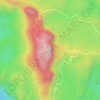
Nombre: Mapa topográfico Dhupgarh, altitud, relieve.
Lugar: Dhupgarh, Pipariya Tahsil, Narmadapuram, Madhya Pradesh, India (22.44986 78.37372 22.44996 78.37382)
Altitud media: 1,079 m
Altitud mínima: 814 m
Altitud máxima: 1,334 m
Gracias por apoyar a este sitio ❤️
Haz una donación
Haz una donación