
Mapa topográfico Sky Valley
Mapa interactivo
Haga clic en el mapa para ver la altitud.
Acerca de este mapa
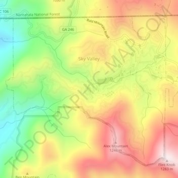
Nombre: Mapa topográfico Sky Valley, altitud, relieve.
Lugar: Sky Valley, Rabun County, Georgia, 30537, United States (34.96659 -83.35311 34.99589 -83.31062)
Altitud media: 973 m
Altitud mínima: 652 m
Altitud máxima: 1,275 m
According to the United States Census Bureau, the city has a total area of 3.0 square miles (7.8 km2), all land. The elevation of the valley floor is approximately 3100 feet above sea level, while areas within the city limits on the slopes of Rabun Bald exceed 4200 feet. Sky Valley is Georgia's highest incorporated city and one of the highest municipalities in the eastern United States.
Otros mapas topográficos
Haga clic en un mapa para ver su topografía, su altitud y su relieve.
Dillard
United States > Georgia > Rabun County
Dillard, Rabun County, Georgia, United States
Altitud media: 691 m
Tiger
United States > Georgia > Rabun County
Tiger, Rabun County, Georgia, United States
Altitud media: 608 m
Clayton
United States > Georgia > Rabun County > Clayton
Clayton, Rabun County, Georgia, 30525, United States
Altitud media: 634 m
Black Rock Mountain State Park
United States > Georgia > Rabun County
Black Rock Mountain State Park, Rabun County, Georgia, 30525, United States
Altitud media: 869 m