
Haz una donación
Mapa topográfico Sutlej River
Haga clic en el mapa para ver la altitud.
Haz una donación
Sutlej River
There is substantial geologic evidence to indicate that prior to 1700 BC, and perhaps much earlier, the Sutlej was an important tributary of the Ghaggar-Hakra River (thought to be the legendary Sarasvati River) rather than the Indus, with various authors putting the redirection from 2500 to 2000 BC, from 5000 to 3000 BC, or before 8000 BC. Geologists believe that tectonic activity created elevation changes which redirected the flow of Sutlej from the southeast to the southwest. If the diversion of the river occurred recently (about 4000 years ago), it may have been responsible for the Ghaggar-Hakra (Saraswati) drying up, causing desertification of Cholistan and the eastern part of the modern state of Sindh, and the abandonment of Harappan settlements along the Ghaggar. However, the Sutlej may have already been captured by the Indus thousands of years earlier.
Haz una donación
Acerca de este mapa
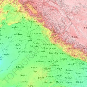
Nombre: Mapa topográfico Sutlej River, altitud, relieve.
Lugar: Sutlej River, India (29.35226 71.05994 31.84358 81.08621)
Altitud media: 1,496 m
Altitud mínima: 95 m
Altitud máxima: 6,949 m
Haz una donación
Otros mapas topográficos
Haga clic en un mapa para ver su topografía, su altitud y su relieve.
Kolkata
Spread roughly north–south along the east bank of the Hooghly River, Kolkata sits within the lower Ganges Delta of eastern India approximately 75 km (47 mi) west of the international border with Bangladesh; the city's elevation is 1.5–9 m (5–30 ft). Much of the city was originally a wetland that was…
Altitud media: 5 m
Gaya
India > Bihar > Gaya Town C.D.Block
Gaya is connected to the rest of India by roads, rail and airways. The Grand Chord section of the Indian Railways passes through Gaya. Gaya Junction railway station railway station is a major junction station serving the city. Gaya Junction has been redeveloped as Model railway station recently and houses all…
Altitud media: 111 m
Haz una donación
Didwana
India > Rajasthan > Didwana Tehsil
Didwana is located at 27°24′N 74°34′E / 27.4°N 74.57°E / 27.4; 74.57. It has an average elevation of 336 metres (1102 feet). City divided in 40 Wards. It is an important station of Jodhpur-Delhi Broad gauge rail route of North West Railway Jodhpur division.
Altitud media: 343 m
Haz una donación
Almora
India > Uttarakhand > Almora
Almora is located at 29°35′50″N 79°39′33″E / 29.5971°N 79.6591°E / 29.5971; 79.6591 in Almora district in Uttarakhand. Almora is situated 365 km north-east the national capital New Delhi and 415 km south-east the state capital Dehradun. It lies in the revenue Division Kumaon and is located…
Altitud media: 1,557 m
Haz una donación
Haz una donación
Pimpri-Chinchwad
India > Maharashtra > Haveli
Pimpri-Chinchwad also known as "PCMC", is a city in the Indian state of Maharashtra. The city is about 15 km (9.3 mi) northwest of the historic city of Pune, at an altitude of 590 m (1,940 ft) above sea level. It is the fifth largest city in Maharashtra and the nineteenth largest city in India and the…
Altitud media: 605 m
Haz una donación
Haz una donación
Haz una donación
ChengiCherla Cheruvu aka Pochamma Kunta
India > Telangana > Medipally mandal > Chengicherla
Altitud media: 510 m
Gokak
India > Karnataka > Gokak taluku
Gokak is second biggest city after Belgaum city in Belgaum district and is surrounded by the Western Ghats. The Ghataprabha River, which has water almost throughout the year, is the chief source of agricultural and drinking water for local people living in the surrounding villages. It has an average elevation…
Altitud media: 593 m
Haz una donación
Karakoram Pass
Historically, the high altitude of the pass and the lack of fodder were responsible for the deaths of countless pack animals while the route was notorious for the trail of bones strewn along the way. There is an almost total absence of vegetation on the approaches to the pass.
Altitud media: 5,521 m
Haz una donación
Katra
India > Jammu and Kashmir > Reasi
Katra is located at 32°59′N 74°57′E / 32.98°N 74.95°E / 32.98; 74.95. It has an average elevation of 875 metres (2,474 feet). The Banganga River passes through the village.
Altitud media: 993 m
Haz una donación
Hosur
India > Tamil Nadu > Hosur
Hosur experiences a tropical savanna climate (Köppen climate classification) with distinct wet and dry seasons. Due to its high elevation, Hosur usually enjoys salubrious and moderate climate throughout the year, with occasional heat waves. The coolest month is January with an average low temperature of 17.1…
Altitud media: 859 m
Haz una donación
Rishikesh
India > Uttarakhand > Rishikesh
Rishikesh is at 30°06′12″N 78°17′41″E / 30.103368°N 78.294754°E / 30.103368; 78.294754. It has an average elevation of 372 metres (1,220 ft). The town is located in the Tehri Garhwal region of the northern Indian state of Uttarakhand.
Altitud media: 497 m
Haz una donación
Solapur
India > Maharashtra > Solapur North
Solapur is located at 17°41′N 75°55′E / 17.68°N 75.92°E / 17.68; 75.92. It has an average elevation of 458 metres (1502 feet). It is bordered by Ahmednagar district on the north; Osmanabad district on the north and northeast.
Altitud media: 469 m
Haz una donación
Haz una donación
Haz una donación
Haz una donación
Haz una donación
Haz una donación
Haz una donación
Kathua
India > Jammu and Kashmir > Kathua
Kathua is located at 32°22′N 75°31′E / 32.37°N 75.52°E / 32.37; 75.52. It has an average elevation of 393 metres (1,289 ft). The city is surrounded by three rivers. Ravi is 7 km (4.3 mi) down Kathua while Ujjh is about 11 km (6.8 mi) ahead on Jammu Highway. Kathua itself is situated along the…
Altitud media: 411 m
Haz una donación
Haz una donación
Haz una donación
Haz una donación
Karkala
India > Karnataka > Karkala taluk
Karla is located at 13°12′N 74°59′E / 13.2°N 74.98°E / 13.2; 74.98. It has an average elevation of 81 metres (265 feet).
Altitud media: 80 m
Haz una donación
Haz una donación